IMAGES TAKEN NEAR TO
Brook Close, CARLISLE, CA5 6PW
Introduction
This page details the photographs taken nearby to Brook Close, CA5 6PW by members of the Geograph project.
The Geograph project started in 2005 with the aim of publishing, organising and preserving representative images for every square kilometre of Great Britain, Ireland and the Isle of Man.

There are currently over 7.5m images from over14,400 individuals and you can help contribute to the project by visiting https://www.geograph.org.uk
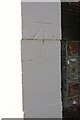
Image Map (18 Images)


Getting Data...Please wait
Leaflet Map data © OpenStreetMap
Images are licensed for reuse under creativecommons.org/licenses/by-sa/2.0
Notes
- Clicking on the map will re-center to the selected point.
- The higher the marker number, the further away the image location is from the centre of the postcode.
Image Listing (18 Images Found)
Images are licensed for reuse under creativecommons.org/licenses/by-sa/2.0
Image
Details
Distance
1
Milestone beside wall in front of Terrona Cottage
There is an Ordnance Survey benchmark Image on top of the milestone
Image: © Luke Shaw
Taken: 13 Aug 2019
0.11 miles
2
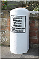
Old Milestone by the former A595 in Thursby
Metal plate attached to stone post by the former A595, in parish of THURSBY (ALLERDALE District), North side of Thursby Village Green, against wall in pavement, on North side of road. Carlisle red stone and curved plate, erected by the Cockermouth & Carlisle turnpike trust in the 19th century.
Inscription reads:-
CARLISLE
6 MILES
WIGTON
5 MILES
COCKERMOUTH
20½ MILES
Carved benchmark and rivet on top.
Grade II Listed. List Entry Number: 1144642
https://historicengland.org.uk/listing/the-list/list-entry/1144642
Milestone Society National ID: CU_CLCM06.
Image: © CF Smith
Taken: 12 Jan 2006
0.11 miles
3
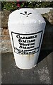
Old milestone with benchmark outside Terrona Cottage
Ordnance Survey rivet benchmark described on the Bench Mark Database at www.bench-marks.org.uk/bm33882. The benchmark was levelled at 118.946 feet above Liverpool Datum during the 1843/4 Kirkby Kendal to Carlisle Survey: the surveyor's description was 'No. 362. Mark on the 6th milestone from Carlisle ; 3.57 ft. above surface'. The mark was verified in 1969 with a levelled height of 36.354m above Newlyn Datum
Image: © Luke Shaw
Taken: 13 Aug 2019
0.11 miles
4
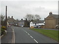
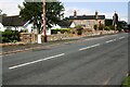
Thursby, Cumbria
The village of Thursby lies to the south west of Carlisle.
Image: © Malc McDonald
Taken: 24 Apr 2015
0.11 miles
5
Start of footpath from Evening Hill to Matty Lonning
Image: © Roger Templeman
Taken: 13 Aug 2019
0.16 miles
6

Brunswick House
There is an Ordnance Survey benchmark Image on the near corner of the bungalow on the 6th quoin above its side path
Image: © Luke Shaw
Taken: 13 Aug 2019
0.18 miles
7
Benchmark on Brunswick House
I am not sure that this is a real Ordnance Survey cut mark benchmark, but possibly recut on the site of a mark levelled at 116.879 feet above Liverpool Datum during the 1843/4 Kirkby Kendal to Carlisle Survey. The surveyor's description was 'No. 361. Mark on South corner of Mr. Mark's house, Thursby Village ; 5.89 ft. above surface'
Image: © Luke Shaw
Taken: 13 Aug 2019
0.18 miles
8
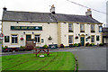
The Ship Inn, Thursby
A traditional village pub which dates from the 18th century (pub website http://www.shipinnthursby.co.uk/ ).
Image: © Rose and Trev Clough
Taken: 21 Sep 2013
0.18 miles
9
The Ship Inn, Thursby - April 2017 (1)
18th Century Inn which was the birthplace of Sir Thomas Bouch, the Victorian engineer.
Acquired by the State Management Scheme at an undiscovered date, Scheme records show it was sold to Scottish & Newcastle on 17 April 1973. Still trading.
This is the back of the premises - the front being in shadow. For a 2013 view, see: Image] .
For other views taken in April 2017, see: Image] , Image] , Image] , Image] and Image] .
For information on Sir Thomas Bouch, see Wikipedia at: https://en.wikipedia.org/wiki/Thomas_Bouch
Photograph is for record only - I have no connection with this business and cannot advise on its products or services.
Image: © The Carlisle Kid
Taken: 23 Apr 2017
0.19 miles
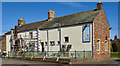
10
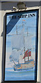
The Ship Inn, Thursby - April 2017 (2)
The pub sign, depicting a Royal Navy warship (probably a frigate) dating from the period 1707-1805.
For information on this building, see: Image] .
Image: © The Carlisle Kid
Taken: 23 Apr 2017
0.19 miles