IMAGES TAKEN NEAR TO
Thursby, CARLISLE, CA5 6NP
Introduction
This page details the photographs taken nearby to CA5 6NP by members of the Geograph project.
The Geograph project started in 2005 with the aim of publishing, organising and preserving representative images for every square kilometre of Great Britain, Ireland and the Isle of Man.

There are currently over 7.5m images from over14,400 individuals and you can help contribute to the project by visiting https://www.geograph.org.uk
Image Map (Loading...)


Getting Data...Please wait
Leaflet Map data © OpenStreetMap
Images are licensed for reuse under creativecommons.org/licenses/by-sa/2.0
Notes
- Clicking on the map will re-center to the selected point.
- The higher the marker number, the further away the image location is from the centre of the postcode.
Image Listing (7 Images Found)
Images are licensed for reuse under creativecommons.org/licenses/by-sa/2.0
Image
Details
Distance
1
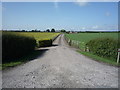
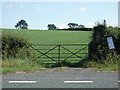
Track to Wood Farm
Looking north from the A595.
Image: © JThomas
Taken: 18 Jun 2016
0.13 miles
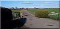
2
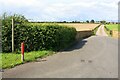
Farm access road and footpath to Wood Farm from north side of A595
Ordnance Survey records indicate that a benchmark was levelled at 139.438 feet above Liverpool Datum on a gatepost here during the 1843/4 Kirkby Kendal to Carlisle Survey. The surveyor's description was 'No. 364. Mark on pier of gate at West side of road ; 4.38 ft. above surface'. The gateway has been remodelled in recent times
Image: © Luke Shaw
Taken: 13 Aug 2019
0.14 miles
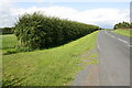
3
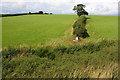
Looking north to fields from A595 verge
Ordnance Survey records indicate that a benchmark was levelled at 147.824 feet above on a gatepost at this location during the Kirkby Kendal to Carlisle Survey. Maps from 1888 no longer show the mark so it was probably an early loss. The surveyor's description was 'No. 365. Mark on West pier of gate, at North side of road ; 4.80 ft. above surface'
Image: © Roger Templeman
Taken: 13 Aug 2019
0.16 miles
6
Wood Farm Entrance.
A well maintained drive, gates, fields, hedges set this farm off well.
Image: © John Holmes
Taken: 9 Feb 2006
0.20 miles
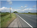
7
Road heading NE from Thursby towards A595
Ordnance Survey records indicate that a benchmark was levelled at 134.605 feet above Liverpool Datum on a gatepost here during the 1843/4 Kirkby Kendal to Carlisle Survey. The surveyor's description was 'No. 363. Mark on East pier of gate, at South side of road ; 2.78 ft. above surface'.
Image: © Luke Shaw
Taken: 13 Aug 2019
0.24 miles