IMAGES TAKEN NEAR TO
Great Orton, CARLISLE, CA5 6NE
Introduction
This page details the photographs taken nearby to CA5 6NE by members of the Geograph project.
The Geograph project started in 2005 with the aim of publishing, organising and preserving representative images for every square kilometre of Great Britain, Ireland and the Isle of Man.

There are currently over 7.5m images from over14,400 individuals and you can help contribute to the project by visiting https://www.geograph.org.uk
Image Map
Images are licensed for reuse under creativecommons.org/licenses/by-sa/2.0
Notes
- Clicking on the map will re-center to the selected point.
- The higher the marker number, the further away the image location is from the centre of the postcode.
Image Listing (7 Images Found)
Images are licensed for reuse under creativecommons.org/licenses/by-sa/2.0
Image
Details
Distance
1
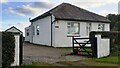
Moss Giel, bungalow on SE side of road east of Great Orton
Image: © Roger Templeman
Taken: 12 Oct 2023
0.03 miles
3
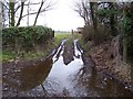
Wet Footpath track
No more than a few inches but a nuisance.
Image: © John Holmes
Taken: 31 Mar 2006
0.09 miles
4
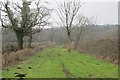
Green lane, Orton Moss
A wide strip of uncultivated ground leads to the woods of Orton Moss.
Image: © Richard Webb
Taken: 13 Feb 2015
0.10 miles
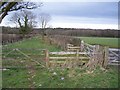
5
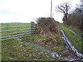
Footpath and field gate.
the footpath goes up the track just up from the flooded entrance.
Image: © John Holmes
Taken: 31 Mar 2006
0.13 miles
6
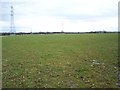
Waterlogged farmland.
Just when the farmers are wanting to turn stock out to graze but will be held up now until the ground dries up a bit.
Image: © John Holmes
Taken: 31 Mar 2006
0.13 miles
7
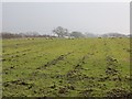
Sheep, Great Orton
Signs of recent drainage work on this field.
Image: © Richard Webb
Taken: 13 Feb 2015
0.23 miles