IMAGES TAKEN NEAR TO
Broad View, CARLISLE, CA5 6LY
Introduction
This page details the photographs taken nearby to Broad View, CA5 6LY by members of the Geograph project.
The Geograph project started in 2005 with the aim of publishing, organising and preserving representative images for every square kilometre of Great Britain, Ireland and the Isle of Man.

There are currently over 7.5m images from over14,400 individuals and you can help contribute to the project by visiting https://www.geograph.org.uk
Image Map
Images are licensed for reuse under creativecommons.org/licenses/by-sa/2.0
Notes
- Clicking on the map will re-center to the selected point.
- The higher the marker number, the further away the image location is from the centre of the postcode.
Image Listing (34 Images Found)
Images are licensed for reuse under creativecommons.org/licenses/by-sa/2.0
Image
Details
Distance
1
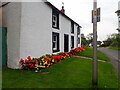
Blooming lovely!
A great show of begonias outside a house in Great Orton
Image: © Eirian Evans
Taken: 10 Sep 2020
0.01 miles
3
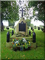
War Memorial, St Giles' Church, Great Orton
Great Orton War Memorial is situated within the churchyard. The memorial commemorates nine local servicemen who fell in the First World War. It was unveiled and dedicated on 30 May 1920 by the rector, the Reverend Canon W P Gillbanks, and the Bishop of Barrow in Furness. The boulder that forms the main part of the memorial was apparently found by the rector in a field at the Flatt. The surrounding shell cases and chains are mentioned in an account of the unveiling.
Image: © Eirian Evans
Taken: 10 Sep 2020
0.04 miles
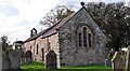
4
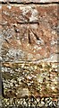
Benchmark on St Giles Church
Ordnance Survey cut mark benchmark levelled at 63.825m above Newlyn Datum verified 1961
Image: © Roger Templeman
Taken: 12 Oct 2023
0.05 miles
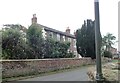
5
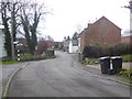
Village street, Great Orton
Looking south; the road to Carlisle branches off to the left.
Image: © Oliver Dixon
Taken: 25 Jan 2016
0.05 miles
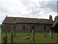
6
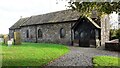
St Giles Church
There is an Ordnance Survey benchmark Image on the right hand side of the church at its near corner. The church has had a St Kernigern dedication previously.
Image: © Roger Templeman
Taken: 12 Oct 2023
0.05 miles
7
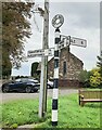
Direction Sign - Signpost in Great Orton
Located on the northeast side of the junction at the north end of Great Orton. Orton parish. 3 arms and annulus finial. See also http://www.geog.port.ac.uk/webmap/thelakes/photos/bue99.jpg.
Milestone Society National ID: CU_NY3254
Image: © B Todd
Taken: 30 Sep 2023
0.05 miles
8

Ordnance Survey Cut Mark
This can be found on the wall of St Giles Church in Great Orton.
For more detail see : http://www.bench-marks.org.uk/bm62717
Image: © Peter Wood
Taken: 27 Sep 2014
0.05 miles
9
The Church of St Giles at Great Orton
Viewed from the south.
Image: © Peter Wood
Taken: 27 Sep 2014
0.05 miles