IMAGES TAKEN NEAR TO
Holme Croft, CARLISLE, CA5 6LQ
Introduction
This page details the photographs taken nearby to Holme Croft, CA5 6LQ by members of the Geograph project.
The Geograph project started in 2005 with the aim of publishing, organising and preserving representative images for every square kilometre of Great Britain, Ireland and the Isle of Man.

There are currently over 7.5m images from over14,400 individuals and you can help contribute to the project by visiting https://www.geograph.org.uk
Image Map
Images are licensed for reuse under creativecommons.org/licenses/by-sa/2.0
Notes
- Clicking on the map will re-center to the selected point.
- The higher the marker number, the further away the image location is from the centre of the postcode.
Image Listing (6 Images Found)
Images are licensed for reuse under creativecommons.org/licenses/by-sa/2.0
Image
Details
Distance
3
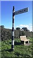
Cumberland County Council finger signpost at T-junction NE of Baldwinholme
The signpost has Milestone Society National ID: CU_NY3352A
Image: © Roger Templeman
Taken: 12 Oct 2023
0.15 miles
4
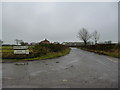
Road to Great Orton from Orton Grange at Baldwinholme T-junction
There is a Cumberland County Council signpost Image with a single arm pointing to Baldwinholme on the verge
Image: © Roger Templeman
Taken: 12 Oct 2023
0.16 miles
5
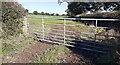
Gateway from northeast side of minor road to field with sheep north of Baldwinholme
Image: © Luke Shaw
Taken: 12 Oct 2023
0.19 miles
6
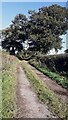
Track into farmland north of Baldwinholme
Image: © Luke Shaw
Taken: 12 Oct 2023
0.24 miles