IMAGES TAKEN NEAR TO
Orton Rigg, Great Orton, CARLISLE, CA5 6LL
Introduction
This page details the photographs taken nearby to CA5 6LL by members of the Geograph project.
The Geograph project started in 2005 with the aim of publishing, organising and preserving representative images for every square kilometre of Great Britain, Ireland and the Isle of Man.

There are currently over 7.5m images from over14,400 individuals and you can help contribute to the project by visiting https://www.geograph.org.uk
Image Map (Loading...)


Getting Data...Please wait
Leaflet Map data © OpenStreetMap
Images are licensed for reuse under creativecommons.org/licenses/by-sa/2.0
Notes
- Clicking on the map will re-center to the selected point.
- The higher the marker number, the further away the image location is from the centre of the postcode.
Image Listing (4 Images Found)
Images are licensed for reuse under creativecommons.org/licenses/by-sa/2.0
Image
Details
Distance
1
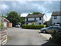
Orton Rigg
The end of a short cul-de-sac.
Image: © David Purchase
Taken: 6 Jun 2019
0.04 miles
2
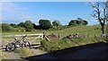
Orton Rigg Farm
Start of the footpath that leads from Orton Rigg Farm to Baldwinholme.
Image: © Andy Connor
Taken: 15 Jul 2018
0.05 miles
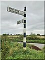
3
Direction Sign - Signpost opposite Orton Rigg drive
Located south of Great Orton on the west side of the road opposite the drive to Orton Rigg. Orton parish. 1 arm and pawn finial.
Milestone Society National ID: CU_NY3252B
Image: © B Todd
Taken: 30 Sep 2023
0.15 miles
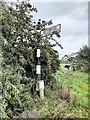
4
Direction Sign - Signpost south of Great Orton
Located on the north side of a junction between Great Orton and Orton Rigg. Orton parish. 3 arms, 1 missing, and pawn finial.
Milestone Society National ID: CU_NY3252A
Image: © B Todd
Taken: 30 Sep 2023
0.22 miles