IMAGES TAKEN NEAR TO
Solway View, CARLISLE, CA5 6HR
Introduction
This page details the photographs taken nearby to Solway View, CA5 6HR by members of the Geograph project.
The Geograph project started in 2005 with the aim of publishing, organising and preserving representative images for every square kilometre of Great Britain, Ireland and the Isle of Man.

There are currently over 7.5m images from over14,400 individuals and you can help contribute to the project by visiting https://www.geograph.org.uk
Image Map (Loading...)


Getting Data...Please wait
Leaflet Map data © OpenStreetMap
Images are licensed for reuse under creativecommons.org/licenses/by-sa/2.0
Notes
- Clicking on the map will re-center to the selected point.
- The higher the marker number, the further away the image location is from the centre of the postcode.
Image Listing (11 Images Found)
Images are licensed for reuse under creativecommons.org/licenses/by-sa/2.0
Image
Details
Distance
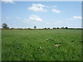
2
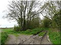
Public footpath to Burgh Moor House
Probably very squelchy when wet.
Image: © Rose and Trev Clough
Taken: 8 May 2010
0.10 miles
3
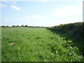
Farmland and hedgerow, Kirkbampton
Off the B5307.
Image: © JThomas
Taken: 28 May 2016
0.11 miles
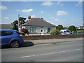
4
Primary school and village hall, Kirkbampton
The school is behind the cherry trees, the hall to the right of the bench.
Image: © Rose and Trev Clough
Taken: 8 May 2010
0.11 miles
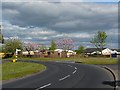
6
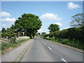
Heading east from Kirkbampton
On the B5307.
Image: © JThomas
Taken: 28 May 2016
0.12 miles
7
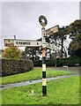
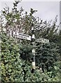
Direction Sign – Signpost on the B5307 in Kirkbampton
Located on the northwest side of the junction of the B5307 and Oaks Lane in Kirkbampton parish. 3 arms and annulus finial.
Milestone Society National ID: CU_NY3056
Image: © B Todd
Taken: 26 Oct 2023
0.12 miles
8
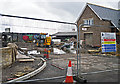
Building site adjacent to Hill Farm
A new housing development on land previously occupied by old farm buildings.
Image: © Rose and Trev Clough
Taken: 10 May 2014
0.20 miles
9
Street scene at Thurstonfield in Cumbria
Image: © James Denham
Taken: 3 Jul 2010
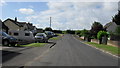
0.20 miles
10
Direction Sign - Signpost on the B5307 in Thurstonfield
Located on the south side of the T junction on the B5307 at Thurstonfield. Burgh by Sands parish. 3 arms and annulus finial.
Milestone Society National ID: CU_NY3156A
Image: © B Todd
Taken: 30 Sep 2023
0.21 miles