IMAGES TAKEN NEAR TO
Moorhouse Road, CARLISLE, CA5 6EJ
Introduction
This page details the photographs taken nearby to Moorhouse Road, CA5 6EJ by members of the Geograph project.
The Geograph project started in 2005 with the aim of publishing, organising and preserving representative images for every square kilometre of Great Britain, Ireland and the Isle of Man.

There are currently over 7.5m images from over14,400 individuals and you can help contribute to the project by visiting https://www.geograph.org.uk
Image Map
Images are licensed for reuse under creativecommons.org/licenses/by-sa/2.0
Notes
- Clicking on the map will re-center to the selected point.
- The higher the marker number, the further away the image location is from the centre of the postcode.
Image Listing (16 Images Found)
Images are licensed for reuse under creativecommons.org/licenses/by-sa/2.0
Image
Details
Distance
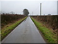
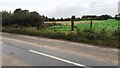
2
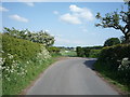
Bend in the road near Sunnyside
Heading south east.
Image: © JThomas
Taken: 28 May 2016
0.04 miles
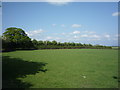
5
View northwest along rural road heading for Hosket Hill
Image: © Luke Shaw
Taken: 2 Oct 2023
0.11 miles
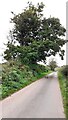
6
Field gateway from bend in road east of Hosket Hill
Image: © Luke Shaw
Taken: 2 Oct 2023
0.14 miles
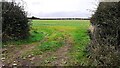
7
Field gateway on north side of B5307 west of Kirksteads
Image: © Luke Shaw
Taken: 2 Oct 2023
0.15 miles
8
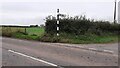
Finger signpost at junction of B5307 and minor road to Hosket Hill
Ordnance Survey records indicate that a benchmark was levelled at 35.863m above Newlyn Datum in 1962 on a gatepost at the left hand side of the gateway to the left of the signpost. The gatepost has been replaced by a wooden one.
Image: © Roger Templeman
Taken: 2 Oct 2023
0.15 miles