IMAGES TAKEN NEAR TO
Powburgh Gardens, CA5 6EE
Introduction
This page details the photographs taken nearby to Powburgh Gardens, CA5 6EE by members of the Geograph project.
The Geograph project started in 2005 with the aim of publishing, organising and preserving representative images for every square kilometre of Great Britain, Ireland and the Isle of Man.

There are currently over 7.5m images from over14,400 individuals and you can help contribute to the project by visiting https://www.geograph.org.uk
Image Map
Images are licensed for reuse under creativecommons.org/licenses/by-sa/2.0
Notes
- Clicking on the map will re-center to the selected point.
- The higher the marker number, the further away the image location is from the centre of the postcode.
Image Listing (41 Images Found)
Images are licensed for reuse under creativecommons.org/licenses/by-sa/2.0
Image
Details
Distance
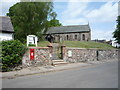
1
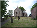
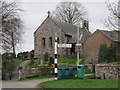
St Mary's Church, Beaumont
Seen from Hadrian's Wall National Trail http://www.nationaltrail.co.uk/hadrianswall/
Image: © Oliver Dixon
Taken: 22 Aug 2008
0.01 miles
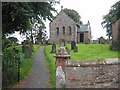
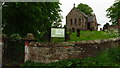
3
St. Mary's Church, Beaumont
A late 12th century church with 18th and 19th century restorations (more information from English Heritage : www.imagesofengland.org.uk/Details/Default.aspx?id=78189 ).
The church was built on the site of a Roman milecastle, using stones from Hadrian's Wall http://www.ctfc.org.uk/index.php?option=com_sobi2&sobi2Task=sobi2Details&catid=2&sobi2Id=199&Itemid=83 .
Image: © Rose and Trev Clough
Taken: 12 May 2012
0.02 miles
4
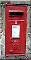
Close up, Elizabeth II postbox, St Mary's Church, Beaumont
Postbox No. CA5 30.
Image: © JThomas
Taken: 28 May 2016
0.02 miles
5
Elizabeth II postbox, St Mary's Church, Beaumont
Postbox No. CA5 30.
Image: © JThomas
Taken: 28 May 2016
0.02 miles
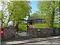
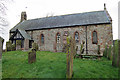
6
Beaumont, Cumbria - St Mary's Church
Originally constructed in the late 13th century using stone from Hadrian’s wall it is built on the top of a Norman motte and bailey and on the site of a Roman milecastle.
Image: © Colin Park
Taken: 16 May 2022
0.02 miles
7
St Mary's Church
The church dates from the 12th century, and many of the stones were taken from Hadrian's Wall.
Image: © Anne Burgess
Taken: 7 Feb 2017
0.02 miles
9
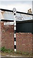
Old Direction Sign - Signpost in Beaumont
Annulus finial - 2 arms; Cumberland named halo by the UC road, in parish of Beaumont (Carlisle District), Beaumont.
Surveyed
Milestone Society National ID: CU_NY3459A
Image: © Milestone Society
Taken: Unknown
0.03 miles