IMAGES TAKEN NEAR TO
The Pack, CARLISLE, CA5 6BE
Introduction
This page details the photographs taken nearby to The Pack, CA5 6BE by members of the Geograph project.
The Geograph project started in 2005 with the aim of publishing, organising and preserving representative images for every square kilometre of Great Britain, Ireland and the Isle of Man.

There are currently over 7.5m images from over14,400 individuals and you can help contribute to the project by visiting https://www.geograph.org.uk
Image Map
Images are licensed for reuse under creativecommons.org/licenses/by-sa/2.0
Notes
- Clicking on the map will re-center to the selected point.
- The higher the marker number, the further away the image location is from the centre of the postcode.
Image Listing (90 Images Found)
Images are licensed for reuse under creativecommons.org/licenses/by-sa/2.0
Image
Details
Distance
1
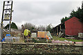
Cluttered Farm Yard
Not everywhere in Burgh-by-Sands is pretty!
Image: © Anne Burgess
Taken: 7 Feb 2017
0.02 miles
2
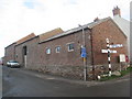
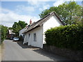
Farm buildings, Burgh by Sands (2)
An interesting but somewhat altered set of buildings. Built largely of brick but on a stone base. These barns mark the north western boundary of a Roman Fort.
Image: © Jonathan Thacker
Taken: 26 Nov 2010
0.05 miles
3
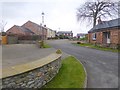
Milton Lane
Small modern housing estate on the north side of the village of Burgh-by-Sands.
Image: © Oliver Dixon
Taken: 25 Jan 2016
0.05 miles
4
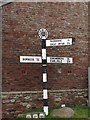
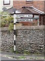
Old Direction Sign - Signpost in Burgh by Sands, Carlisle
Annulus finial - 3 arms; Cumberland named halo by the UC road, in parish of Burgh by Sands (Carlisle District), Burgh.
Surveyed
Milestone Society National ID: CU_NY3259A
Image: © Milestone Society
Taken: Unknown
0.06 miles
5
Old Direction Sign - Signpost by crossroads, Burgh by Sands Parish
Spike finial - 2 arms; by the UC road, in parish of Burgh by Sands (Carlisle District), Burgh.
Surveyed
Milestone Society National ID: CU_NY3259B
Image: © Milestone Society
Taken: Unknown
0.06 miles
6
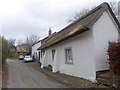
Thatched cottage in North End
On the road which leads north out of Burgh-by-Sands towards the marshes.
Image: © Oliver Dixon
Taken: 25 Jan 2016
0.06 miles
7
North End Cottage, Burgh by Sands
A late-17thC thatched cottage, with late-18thC barn attached https://historicengland.org.uk/listing/the-list/list-entry/1087495
Image: © M J Richardson
Taken: 1 Oct 2021
0.07 miles
9
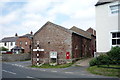
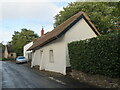
Farm building, Burgh by Sands
Showing position of Postbox No. CA5 283.
See Image] for postbox.
Image: © JThomas
Taken: 28 May 2016
0.07 miles
10
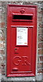
Close up, George V postbox, Burgh by Sands
Postbox No. CA5 283
See Image] for context.
Image: © JThomas
Taken: 28 May 2016
0.07 miles