IMAGES TAKEN NEAR TO
Burgh-by-Sands, CARLISLE, CA5 6BB
Introduction
This page details the photographs taken nearby to CA5 6BB by members of the Geograph project.
The Geograph project started in 2005 with the aim of publishing, organising and preserving representative images for every square kilometre of Great Britain, Ireland and the Isle of Man.

There are currently over 7.5m images from over14,400 individuals and you can help contribute to the project by visiting https://www.geograph.org.uk
Image Map
Images are licensed for reuse under creativecommons.org/licenses/by-sa/2.0
Notes
- Clicking on the map will re-center to the selected point.
- The higher the marker number, the further away the image location is from the centre of the postcode.
Image Listing (53 Images Found)
Images are licensed for reuse under creativecommons.org/licenses/by-sa/2.0
Image
Details
Distance
1
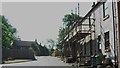
Burgh by Sands
Houses under renovation at St. Lawrence Place in the village.
Image: © James Denham
Taken: 3 Jul 2010
0.06 miles
2
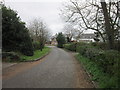
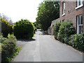
Lawrence Lane, Burgh by Sands
Taken just off route.
Image: © Ian S
Taken: 2 Apr 2012
0.06 miles
3
Sundial on the wall of a house
The date on the sundial is 1909.
Image: © Rose and Trev Clough
Taken: 16 Mar 2016
0.06 miles
4
Station Road, Burgh by Sands
The station went when the railway closed in 1964 under Beeching
Image: © Oliver Dixon
Taken: 19 Jul 2006
0.06 miles
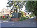
5
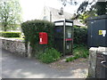
Elizabeth II postbox and phonebox, Burgh by Sands
Postbox No. CA5 157.
See Image] for close up.
Image: © JThomas
Taken: 28 May 2016
0.07 miles
6
Station Road, Burgh by Sands
Looking south - the station and railway are long gone.
Image: © JThomas
Taken: 28 May 2016
0.07 miles
7
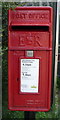
Close up, Elizabeth II postbox, Burgh by Sands
Postbox No. CA5 157.
See Image] for wider view.
Image: © JThomas
Taken: 28 May 2016
0.07 miles
8
Station Road, Burgh by Sands
The station has, of course, long since disappeared!
Image: © David Purchase
Taken: 1 Jun 2013
0.08 miles
9
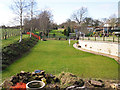
Course of former canal and railway
The Carlisle Canal, opened in 1823, passed through here on its route to Port Carlisle. By 1854 it had been drained and replaced by a railway (later extended to Silloth) which itself closed in 1964.
Now converted to domestic gardens, as seen from the end of St Lawrence Lane.
Image: © Rose and Trev Clough
Taken: 16 Mar 2016
0.08 miles
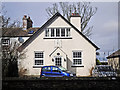
10
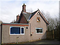
The Old Station, Burgh by Sands
Now a private house.
The station opened in 1854, originally on the Port Carlisle Railway http://www.cumbria-railways.co.uk/port-carlisle-railway.html . In 1856, the section of line Burgh was on was taken over by the new Carlisle & Silloth Bay Railway http://www.cumbria-railways.co.uk/carlisle_silloth_bay_railway.html . The route closed in 1964.
The distinctive gabled roof of this building can be seen on a photo taken in 1961 Image .
An inscription around the triangular window says 'AD 1891 CHAs. BOYD C.E.'. Mr Boyd was engineer to the Carlisle & Silloth railway.
Image: © Rose and Trev Clough
Taken: 16 Mar 2016
0.10 miles