IMAGES TAKEN NEAR TO
Armathwaite, CARLISLE, CA4 9SY
Introduction
This page details the photographs taken nearby to CA4 9SY by members of the Geograph project.
The Geograph project started in 2005 with the aim of publishing, organising and preserving representative images for every square kilometre of Great Britain, Ireland and the Isle of Man.

There are currently over 7.5m images from over14,400 individuals and you can help contribute to the project by visiting https://www.geograph.org.uk
Image Map
Images are licensed for reuse under creativecommons.org/licenses/by-sa/2.0
Notes
- Clicking on the map will re-center to the selected point.
- The higher the marker number, the further away the image location is from the centre of the postcode.
Image Listing (10 Images Found)
Images are licensed for reuse under creativecommons.org/licenses/by-sa/2.0
Image
Details
Distance
1
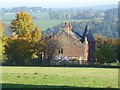
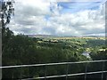
Eden Brows
Country house poised above the River Eden.
Image: © Oliver Dixon
Taken: 25 Oct 2016
0.01 miles
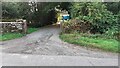
2
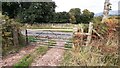
Field gateway on SW side of road at Eden Brows
There is an Ordnance Survey benchmark Image on the inside face of the left hand gatepost at the gateway
Image: © Roger Templeman
Taken: 20 Sep 2021
0.10 miles
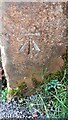
3
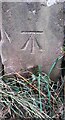
Benchmark on gatepost at field gateway on SW side of road at Eden Brows
Ordnance Survey cut mark benchmark levelled at 131.352m above Newlyn Datum verified 1972
Image: © Roger Templeman
Taken: 20 Sep 2021
0.12 miles
4
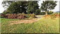
Pile of soil beside field gateway on SW side of road at Eden Brows
Image: © Luke Shaw
Taken: 20 Sep 2021
0.12 miles
5
Edenbrows Wood and the River Eden
Viewed from a passing steam-hauled train on The Dalesman excursion to the Settle-Carlisle line
Image: © Graham Hogg
Taken: 7 Aug 2017
0.16 miles
6
Benchmark on gatepost at entrance to Stone Raise
Ordnance Survey cut mark benchmark levelled at 119.766m above Newlyn Datum verified 1972
Image: © Roger Templeman
Taken: 20 Sep 2021
0.18 miles
7
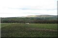
Country above the River Eden
The Settle to Carlisle line runs just in front of the trees, but in a cutting.
Image: © David Purchase
Taken: 24 Dec 2020
0.18 miles
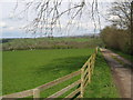
9
Entrance track to Stone Raise from SW side of road at Eden Brows
There is an Ordnance Survey benchmark Image on the inside face of the gatepost at the left hand side of the track
Image: © Roger Templeman
Taken: 20 Sep 2021
0.19 miles
10
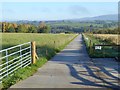
Secondary access road to the Eden Brows Landslip Repair site
In February 2016, a landslip of 500,000 tonnes of material on an embankment above the River Eden necessitated the closure of the Settle and Carlisle line which traverses the top of the bank at this point. A massive £23 million project to stabilise the slope and provide a secure base for the track with pilings 20 metres deep is currently under way. Completion of the project is anticipated in the spring of 2017. Meanwhile a replacement bus service is being operated between Carlisle and Appleby.
Image: © Oliver Dixon
Taken: 25 Oct 2016
0.20 miles