IMAGES TAKEN NEAR TO
Armathwaite, CARLISLE, CA4 9ST
Introduction
This page details the photographs taken nearby to CA4 9ST by members of the Geograph project.
The Geograph project started in 2005 with the aim of publishing, organising and preserving representative images for every square kilometre of Great Britain, Ireland and the Isle of Man.

There are currently over 7.5m images from over14,400 individuals and you can help contribute to the project by visiting https://www.geograph.org.uk
Image Map
Images are licensed for reuse under creativecommons.org/licenses/by-sa/2.0
Notes
- Clicking on the map will re-center to the selected point.
- The higher the marker number, the further away the image location is from the centre of the postcode.
Image Listing (20 Images Found)
Images are licensed for reuse under creativecommons.org/licenses/by-sa/2.0
Image
Details
Distance
1
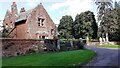
The Lodge at the entrance driveway to Low House
Image: © Luke Shaw
Taken: 20 Sep 2021
0.01 miles
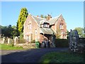
2
The Lodge and entrance to Low House
Image: © Roger Templeman
Taken: 20 Sep 2021
0.01 miles
3
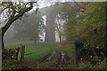
Lodge to Low House
In the floor of the Eden valley.
Image: © Oliver Dixon
Taken: 25 Oct 2016
0.02 miles
4
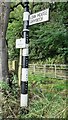
Cumberland County Council finger signpost near Drybeck Viaduct
Behind the signpost is a track which passes under Drybeck Viaduct. Image is another view of the signpost.
Image: © Roger Templeman
Taken: 20 Sep 2021
0.09 miles
5
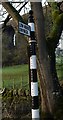
Direction Sign - Signpost west of Drybeck Farm, Hesket Parish
Pawn finial - 2 arms; Cumberland CC square end by the UC road, in parish of Hesket (Eden District), T-junction to Drybeck Farm, North of Armathwaite, on verge beside gateway, West side of road.
To be surveyed
Milestone Society National ID: CU_NY5047
Image: © A O'Connor
Taken: 23 Dec 2017
0.09 miles
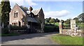
6
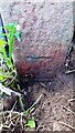
Benchmark at base of gatepost in front of cottages at Folly Brow
Ordnance Survey cut mark benchmark levelled at 68.810m above Newlyn Datum verified 1972
Image: © Roger Templeman
Taken: 20 Sep 2021
0.10 miles
7
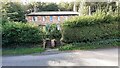
Cottages on west side of road at Folly Brow
There is an Ordnance Survey benchmark Image at the base of the right hand gatepost at the entrance to the cottages
Image: © Roger Templeman
Taken: 20 Sep 2021
0.10 miles
8
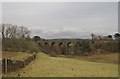
Dry Beck Viaduct
This is one of many spectacular viaducts on the Settle-Carlisle Railway. It has 7 arches, is 80 ft. high, 139 yards long and was built between 1871-1874. The viaduct spans the aptly named Dry Beck.
Image: © Greg Fitchett
Taken: 25 Feb 2012
0.12 miles
9
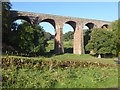
Drybeck Viaduct
Viaduct on the Settle and Carlisle line completed in 1875. It consists of 7 arches with a total length of 129 metres and maximum height of 24 metres.
Image: © Oliver Dixon
Taken: 25 Oct 2016
0.12 miles