IMAGES TAKEN NEAR TO
Warwick Bridge, CARLISLE, CA4 8RN
Introduction
This page details the photographs taken nearby to CA4 8RN by members of the Geograph project.
The Geograph project started in 2005 with the aim of publishing, organising and preserving representative images for every square kilometre of Great Britain, Ireland and the Isle of Man.

There are currently over 7.5m images from over14,400 individuals and you can help contribute to the project by visiting https://www.geograph.org.uk
Image Map (Loading...)


Getting Data...Please wait
Leaflet Map data © OpenStreetMap
Images are licensed for reuse under creativecommons.org/licenses/by-sa/2.0
Notes
- Clicking on the map will re-center to the selected point.
- The higher the marker number, the further away the image location is from the centre of the postcode.
Image Listing (38 Images Found)
Images are licensed for reuse under creativecommons.org/licenses/by-sa/2.0
Image
Details
Distance
1
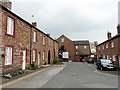
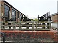
High Buildings, Warwick Bridge
Early 19th century houses, originally built for workers at the mill seen at the end of the terrace Image .
Further information at Images of England : http://www.imagesofengland.org.uk/details/default.aspx?id=77693 and http://www.imagesofengland.org.uk/details/default.aspx?id=77694 .
Image: © Rose and Trev Clough
Taken: 6 May 2012
0.06 miles
2
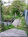
Footpath from Warwick Mill to Burnrigg Road
The path crosses the mill race built to power cotton spinning machines at Image .
Visible further down the slope is another bridge, over the Cairn Beck.
Image: © Rose and Trev Clough
Taken: 6 May 2012
0.06 miles
3
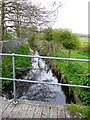
Mill race, Warwick Bridge
View from Image .
From this point the race is culverted underground, being partly exposed near the main building at Warwick Mill - see Image .
Image: © Rose and Trev Clough
Taken: 6 May 2012
0.06 miles
4
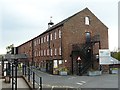
Warwick Mill
Originally a cotton mill (established 1791), later a woollen mill, developed at the end of the 20th century as a business village providing offices, meeting rooms and workshops. More people work on the site today than when textile production ceased in 1977.
The owners' website http://www.warwickmill.co.uk/index.asp includes a history of the mill. Early history, when it was called Langthwaite Mill, at Cumbria Industries http://www.cumbria-industries.org.uk/langthwaite.htm . See also English Heritage description http://www.imagesofengland.org.uk/details/default.aspx?id=77695 .
Image: © Rose and Trev Clough
Taken: 6 May 2012
0.07 miles
5
Winding gear for mill race sluices
Located at Image . The cotton spinning machinery was powered entirely by water until the installation of a steam engine in 1832 http://www.cumbria-industries.org.uk/langthwaite.htm . There is still water in the mill race.
Image: © Rose and Trev Clough
Taken: 6 May 2012
0.07 miles
6
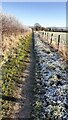
A frosty footpath between Warwick Mill and Allen Grove
Image: © Roger Templeman
Taken: 12 Dec 2022
0.12 miles
7
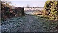
Gate and stone step stile across footpath from Allen Grove to Warwick Mill
Image: © Luke Shaw
Taken: 12 Dec 2022
0.14 miles
9
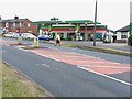
Spar shop and filling station, Warwick Bridge
As is so often found now, the filling station on the busy A69 doubles up as the village shop.
Image: © Oliver Dixon
Taken: 20 Jul 2006
0.17 miles
10
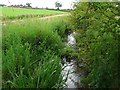
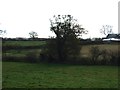
The Trout Beck near Corby Hill
Looking downstream from the road bridge, with Longthwaite Farm over to the left. There are several other streams called "Trout Beck" in Cumbria.
Image: © Rose and Trev Clough
Taken: 4 Jul 2009
0.17 miles