IMAGES TAKEN NEAR TO
Newby East, Wetheral, CARLISLE, CA4 8RA
Introduction
This page details the photographs taken nearby to CA4 8RA by members of the Geograph project.
The Geograph project started in 2005 with the aim of publishing, organising and preserving representative images for every square kilometre of Great Britain, Ireland and the Isle of Man.

There are currently over 7.5m images from over14,400 individuals and you can help contribute to the project by visiting https://www.geograph.org.uk
Image Map
Images are licensed for reuse under creativecommons.org/licenses/by-sa/2.0
Notes
- Clicking on the map will re-center to the selected point.
- The higher the marker number, the further away the image location is from the centre of the postcode.
Image Listing (9 Images Found)
Images are licensed for reuse under creativecommons.org/licenses/by-sa/2.0
Image
Details
Distance
1
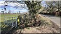
Looking NE along roadside ditch from field gateway at Bankhead
Image: © Roger Templeman
Taken: 8 Mar 2023
0.08 miles
2
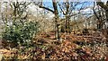
Deciduous woodland on SE side of road near Bankhead
Image: © Luke Shaw
Taken: 8 Mar 2023
0.09 miles
3
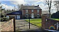
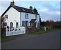
Acorn House on SE side of road near Bankhead
Image: © Luke Shaw
Taken: 8 Mar 2023
0.14 miles
4
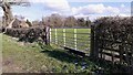
Field gateway on SE side of road heading for Bankhead
Image: © Roger Templeman
Taken: 8 Mar 2023
0.15 miles
6
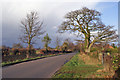
Road at Bank Head
Looking north east. The road is unclassified. A short distance behind the photographer is the village of Newby East. In this direction, the road continues about half a mile before meeting the A689.
Image: © Richard Dorrell
Taken: 27 Feb 2014
0.19 miles
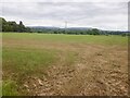
8

View over a gate
Looking south east over pasture land from an unclassified road just south of Newby East village.
Image: © Richard Dorrell
Taken: 27 Feb 2014
0.22 miles
9
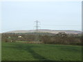
View over pastures
Towards Cold Fell in the distance.
Image: © Jonathan Billinger
Taken: 17 Apr 2007
0.24 miles