IMAGES TAKEN NEAR TO
Warwick-on-Eden, CARLISLE, CA4 8PR
Introduction
This page details the photographs taken nearby to CA4 8PR by members of the Geograph project.
The Geograph project started in 2005 with the aim of publishing, organising and preserving representative images for every square kilometre of Great Britain, Ireland and the Isle of Man.

There are currently over 7.5m images from over14,400 individuals and you can help contribute to the project by visiting https://www.geograph.org.uk
Image Map
Images are licensed for reuse under creativecommons.org/licenses/by-sa/2.0
Notes
- Clicking on the map will re-center to the selected point.
- The higher the marker number, the further away the image location is from the centre of the postcode.
Image Listing (30 Images Found)
Images are licensed for reuse under creativecommons.org/licenses/by-sa/2.0
Image
Details
Distance
1
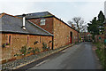
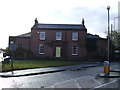
Converted farm buildings, Tithebarn Hill
An old farm redeveloped to provide several homes around a courtyard.
There is a datestone over the archway - 1842.
Image: © Rose and Trev Clough
Taken: 16 Nov 2014
0.01 miles
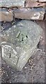
2

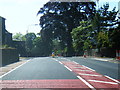
A69 heading east at Warwick-on-Eden
There is an old milestone Image against the wall on the right hand side of the road.
Image: © Roger Templeman
Taken: 16 Jul 2022
0.03 miles
4
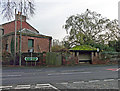
A red sandstone bus stop
On the A69 at Warwick-on-Eden.
Image: © Rose and Trev Clough
Taken: 16 Nov 2014
0.03 miles
6
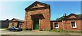
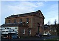
Penney Packaging Ltd on NW side of The Old Chapel
The building's central jut with green doors has two Ordnance Survey benchmarks: an old one near the right hand corner Image, and a newer one near the left hand corner Image
Image: © Roger Templeman
Taken: 16 Jul 2022
0.04 miles
8
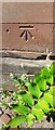
Southwestern benchmark on Penney Packaging Ltd's building
Ordnance Survey cut mark benchmark levelled at 42.136m above Newlyn Datum verified 1972
Image: © Roger Templeman
Taken: 16 Jul 2022
0.04 miles
9
Northeastern benchmark on Penney Packaging Ltd's building
Ordnance Survey cut mark benchmark levelled at 42.351m above Newlyn Datum verified 1972. Also shown on 1888-1913 6" Map levelled at 138.8 feet above Liverpool Datum on 1888-1913 6" Map
Image: © Roger Templeman
Taken: 16 Jul 2022
0.05 miles
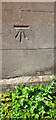
10
Milestone (Carlisle 4,Brampton 5) with benchmark on top
Ordnance Survey rivet benchmark shown on 1888-1913 6" Map as levelled at 142.1 feet above Liverpool Datum
Image: © Roger Templeman
Taken: 16 Jul 2022
0.05 miles