IMAGES TAKEN NEAR TO
Corby Hill, CARLISLE, CA4 8PJ
Introduction
This page details the photographs taken nearby to CA4 8PJ by members of the Geograph project.
The Geograph project started in 2005 with the aim of publishing, organising and preserving representative images for every square kilometre of Great Britain, Ireland and the Isle of Man.

There are currently over 7.5m images from over14,400 individuals and you can help contribute to the project by visiting https://www.geograph.org.uk
Image Map
Images are licensed for reuse under creativecommons.org/licenses/by-sa/2.0
Notes
- Clicking on the map will re-center to the selected point.
- The higher the marker number, the further away the image location is from the centre of the postcode.
Image Listing (40 Images Found)
Images are licensed for reuse under creativecommons.org/licenses/by-sa/2.0
Image
Details
Distance
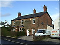
2
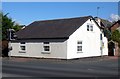
Langley Toll Cottage
The white cottage is on the A69, which was originally a turnpike road. The road was built and maintained by the Carlisle and Brampton Turnpike Trust (in operation 1828-1876). To recover their investment, the trustees installed gates with toll collectors along the route. No doubt the toll cottage will have been much altered since those days.
Image: © Rose and Trev Clough
Taken: 4 Jul 2009
0.02 miles
3
Langley Toll Cottage, Corby Hill
Toll Cottage by the A69, in parish of Hayton (Carlisle District). Langley Toll Cottage, Corby Hill.
To be surveyed
Milestone Society National ID: CB.HAY
Image: © Milestone Society
Taken: Unknown
0.02 miles
5
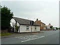
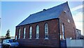
Corby Hill and Warwick Bridge Methodist Chapel
A member here told us the original chapel was the low grey building to the right, and the brick part was added later. Warwick Bridge used to have its own Methodist chapel, but that was converted to housing several years ago.
Image: © Rose and Trev Clough
Taken: 4 Jul 2009
0.03 miles
6
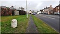
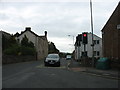
A69 approaching crossroads in Corby Hill
There is a milestone (Brampton 4, Carlisle 5 miles) on the verge in the left foreground.
Image: © Roger Templeman
Taken: 22 Dec 2022
0.04 miles
7
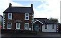
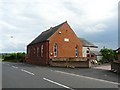
Corby Hill Wesleyan Methodist Chapel
Ordnance Survey documents indicate that a benchmark levelled at 36.119m above Newlyn Datum was verified in 1972 on the end of the wall right of the wooden gate. The wall appears to be rendered now.
Image: © Roger Templeman
Taken: 12 Dec 2022
0.04 miles
8
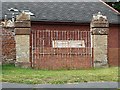
Redundant gates to Langley Hall
Langley Hall was a hotel/function venue until the 1980s or 90s, when it was converted into flats and several houses built in the grounds.
Image: © Rose and Trev Clough
Taken: 4 Jul 2009
0.04 miles
10
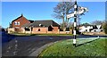
Road junction in Corby Hill
There is a Cumberland County Council finger signpost Image on the verge
Image: © Roger Templeman
Taken: 12 Dec 2022
0.05 miles