IMAGES TAKEN NEAR TO
Warwick-on-Eden, CARLISLE, CA4 8PG
Introduction
This page details the photographs taken nearby to CA4 8PG by members of the Geograph project.
The Geograph project started in 2005 with the aim of publishing, organising and preserving representative images for every square kilometre of Great Britain, Ireland and the Isle of Man.

There are currently over 7.5m images from over14,400 individuals and you can help contribute to the project by visiting https://www.geograph.org.uk
Image Map
Images are licensed for reuse under creativecommons.org/licenses/by-sa/2.0
Notes
- Clicking on the map will re-center to the selected point.
- The higher the marker number, the further away the image location is from the centre of the postcode.
Image Listing (26 Images Found)
Images are licensed for reuse under creativecommons.org/licenses/by-sa/2.0
Image
Details
Distance
1
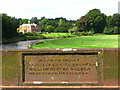
Warwick Bridge
The nearby village of Warwick Bridge is named after the bridge spanning the river Eden, built in 1837. Its history includes the gathering of the Jacobites in November 1745 prior to their attack on Carlisle.
Image: © David Rogers
Taken: 9 Sep 2009
0.01 miles
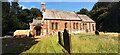
2
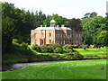
Warwick Hall
Warwick Hall was once owned by the Liddle family. It is a 20th century building done in the neo-Georgian style. An 1828 building once occupied the site but burned down in 1936. The stables at the hall are original Georgian.
Image: © David Rogers
Taken: 9 Sep 2009
0.02 miles
3
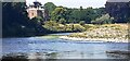
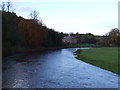
Looking north along River Eden towards Warwick Hall
Image: © Luke Shaw
Taken: 16 Jul 2022
0.02 miles
4
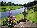
The River Eden at Warwick Hall
The banks opposite provide a nesting place for sand martins.
Warwick Bridge and the spire of St Paul's Church, Holme Eden, can be seen in the distance.
Photo taken at a charity flower festival held at Warwick Hall http://www.warwickhall.org/ .
Image: © Rose and Trev Clough
Taken: 3 Jul 2011
0.05 miles
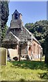
7
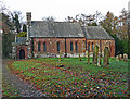
St Leonard's Church
The church dates from the 12th century, with considerable rebuilding during the 19th. A notable surviving feature is the Norman apse (semi-circular end) with external pilasters - a style of decoration rarely seen outside of France.
The parish website has photos of the church interior http://www.edenchurches.co.uk/index.php/photographs/churches/warwick . For architectural details, see English Heritage http://www.imagesofengland.org.uk/Details/Default.aspx?id=77738 .
There is a sign for St Leonard's Church on the A69, for years I thought it referred to this building Image . Only recently found out that the actual St. Leonard's is further along the track, hiding behind some trees.
Image: © Rose and Trev Clough
Taken: 16 Nov 2014
0.11 miles
8
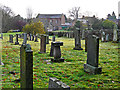
Graveyard at St Leonard's Church
Looking towards Image .
Image: © Rose and Trev Clough
Taken: 16 Nov 2014
0.13 miles
10
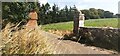
Entrance gateway to Warwick Hall
There is an Ordnance Survey benchmark Image on a stone at the base of the wall right of the gatepost on the right hand side of the entrance drive
Image: © Roger Templeman
Taken: 16 Jul 2022
0.17 miles