IMAGES TAKEN NEAR TO
Broadwath Road, CARLISLE, CA4 8ND
Introduction
This page details the photographs taken nearby to Broadwath Road, CA4 8ND by members of the Geograph project.
The Geograph project started in 2005 with the aim of publishing, organising and preserving representative images for every square kilometre of Great Britain, Ireland and the Isle of Man.

There are currently over 7.5m images from over14,400 individuals and you can help contribute to the project by visiting https://www.geograph.org.uk
Image Map
Images are licensed for reuse under creativecommons.org/licenses/by-sa/2.0
Notes
- Clicking on the map will re-center to the selected point.
- The higher the marker number, the further away the image location is from the centre of the postcode.
Image Listing (5 Images Found)
Images are licensed for reuse under creativecommons.org/licenses/by-sa/2.0
Image
Details
Distance
1
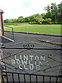
Linton Bowling Club
Situated just off Sandy Lane. There is a clubhouse to the left.
Image: © Rose and Trev Clough
Taken: 28 Jun 2015
0.19 miles
2
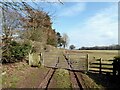
Footpath near Great Corby
The public footpath from Sandy Lane in Great Corby to Broadwath.
Image: © Adrian Taylor
Taken: 7 Mar 2021
0.19 miles
3
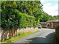
Old traffic sign for school, Sandy Lane
For a closer view and information, see Image .
Image: © Rose and Trev Clough
Taken: 28 Jun 2015
0.22 miles
4
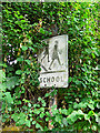
Pre-Worboys school sign, Great Corby
This style of sign was discontinued in the 1960s, following a review of road signage by the Worboys Committee https://en.wikipedia.org/wiki/Worboys_Committee .
The sign is faded and has lost the red warning triangle which used to sit on top of the post (that was still there in 2010, as seen on Google Street View).
It is hiding in a hedge, for location see Image .
Image: © Rose and Trev Clough
Taken: 28 Jun 2015
0.22 miles
5
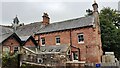
Great Corby primary school and nursery
There is an Ordnance Survey benchmark Image on the right hand corner of the building just through a gate in the wooden fence
Image: © Roger Templeman
Taken: 31 Aug 2021
0.24 miles