IMAGES TAKEN NEAR TO
Greenacres, CARLISLE, CA4 8LU
Introduction
This page details the photographs taken nearby to Greenacres, CA4 8LU by members of the Geograph project.
The Geograph project started in 2005 with the aim of publishing, organising and preserving representative images for every square kilometre of Great Britain, Ireland and the Isle of Man.

There are currently over 7.5m images from over14,400 individuals and you can help contribute to the project by visiting https://www.geograph.org.uk
Image Map
Images are licensed for reuse under creativecommons.org/licenses/by-sa/2.0
Notes
- Clicking on the map will re-center to the selected point.
- The higher the marker number, the further away the image location is from the centre of the postcode.
Image Listing (15 Images Found)
Images are licensed for reuse under creativecommons.org/licenses/by-sa/2.0
Image
Details
Distance
1
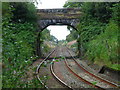
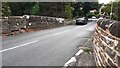
Wetheral Bridge
Bridge carrying the B6263 Steele's Bank over the rail tracks near Wetheral Station.
Image: © David Rogers
Taken: 9 Sep 2009
0.16 miles
2
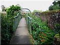
Wetheral Footbridge
Footbridge over the rail tracks near Wetheral Station made by Tubewrights Ltd, Newport, Monmouthshire.
Image: © David Rogers
Taken: 9 Sep 2009
0.17 miles
3
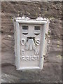
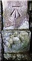
Ordnance Survey Flush Bracket (G3831)
This OS Flush Bracket can be found on the SE parapet of the railway bridge. It marks a point 57.035m above mean sea level.
Image: © Adrian Dust
Taken: 11 Apr 2016
0.18 miles
4
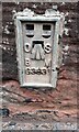
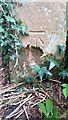
Benchmark on SE parapet of Steeles Bank railway bridge
Ordnance Survey flush bracket (serial identifier G3831) benchmark described on the Bench Mark Database at www.bench-marks.org.uk/bm431
Image: © Roger Templeman
Taken: 31 Aug 2021
0.18 miles
5
Railway bridge NEC2/159 Steeles Bank B6263
There is an Ordnance Survey flush bracket benchmark Image on the near end of the left hand parapet at its junction with a stone wall
Image: © Roger Templeman
Taken: 31 Aug 2021
0.19 miles
6

Entrance to Wetheral Station
There is a path that leads down to the platforms from here. There are other entrances nearer the platforms.
Image: © Danny P Robinson
Taken: 29 May 2008
0.21 miles
7
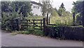
Gateway for track passing houses on SW side of Plains Road
There is an Ordnance Survey benchmark Image on the inside face of the gatepost at the left hand side of the gateway.
Image: © Luke Shaw
Taken: 31 Aug 2021
0.22 miles
8
Benchmark on wall pier at entrance to Edenbank
Ordnance Survey cut mark benchmark described on the Bench Mark Database at www.bench-marks.org.uk/bm32135
Image: © Roger Templeman
Taken: 7 Sep 2021
0.22 miles
9
Benchmark on gatepost at gateway on SW side of Plains Road
Ordnance Survey cut mark benchmark levelled at 54.872m above Newlyn Datum verified 1972
Image: © Roger Templeman
Taken: 31 Aug 2021
0.23 miles
10
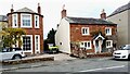
Acorn Bank and Manor Cottage on north side of road
There is an Ordnance Survey benchmark Image on the road end of the party wall between the two houses
Image: © Roger Templeman
Taken: 31 Aug 2021
0.23 miles