IMAGES TAKEN NEAR TO
Great Corby, CARLISLE, CA4 8LL
Introduction
This page details the photographs taken nearby to CA4 8LL by members of the Geograph project.
The Geograph project started in 2005 with the aim of publishing, organising and preserving representative images for every square kilometre of Great Britain, Ireland and the Isle of Man.

There are currently over 7.5m images from over14,400 individuals and you can help contribute to the project by visiting https://www.geograph.org.uk
Image Map
Images are licensed for reuse under creativecommons.org/licenses/by-sa/2.0
Notes
- Clicking on the map will re-center to the selected point.
- The higher the marker number, the further away the image location is from the centre of the postcode.
Image Listing (94 Images Found)
Images are licensed for reuse under creativecommons.org/licenses/by-sa/2.0
Image
Details
Distance
1
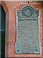
Great Corby War Memorial
This plaque is a roll of honour listing all the men from the village who served in the Great War of 1914-1918. The names of three men killed in action are marked with asterisks - they are also remembered on the parish war memorial at Wetheral http://branches.britishlegion.org.uk/branches/carlisle/ww1-heroes-walk-of-honour/memorial-66-holy-trinity-church-wetheral .
The plaque is located beside the front door at Image .
Image: © Rose and Trev Clough
Taken: 28 Jun 2015
0.09 miles
2
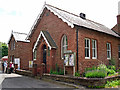
Great Corby Village Hall
Stones above the porch are inscribed 'Reading Room - Built by subscription - A.D. 1877'. A caretaker's cottage (far left) was added twenty years later, to commemorate Queen Victoria's Diamond Jubilee.
A memorial plaque to those who served in the First World War is mounted on the right hand side of the porch - see Image .
Image: © Rose and Trev Clough
Taken: 28 Jun 2015
0.09 miles
3
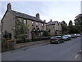
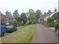
Main street, Great Corby
The houses line the main street of the village just south of the railway http://www.geograph.org.uk/photo/6155571 .
Image: © Rudi Winter
Taken: 6 Aug 2018
0.09 miles
4
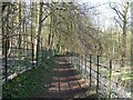
Footpath in Glen Willie
The public footpath runs from Sandy Lane to Corby Gates Level Crossing. The metal railings enclosing the path were installed by the Corby Castle Estate.
Image: © Adrian Taylor
Taken: 7 Mar 2021
0.10 miles
6
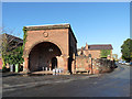
Great Corby village
This imposing structure in the centre of Great Corby is a former blacksmith's shop, built in 1833 for the Howard family of Corby Castle, in imitation of Vulcan's forge. It is a Grade II listed building - more information at http://list.historicengland.org.uk/resultsingle.aspx?uid=1335516. It appears now to serve as the beer cellar for the Queen's Inn on the opposite side of the village green. (information supplied by Dave Dunford)
Image: © Oliver Dixon
Taken: 5 Nov 2014
0.11 miles
7
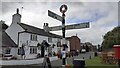
Cumberland County Council signpost and The Queen Inn
The signpost has Milestone Society National ID: CU_NY4754A
Image: © Roger Templeman
Taken: 31 Aug 2021
0.11 miles
9
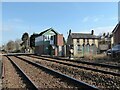
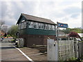
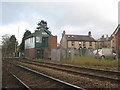
Corby Gates Signal Box
On the Newcastle to Carlisle Railway adjacent to Corby Gates Level Crossing, this is a fringe signal box for the Carlisle Power Box.
The ground signal controls movements over a trailing crossover beyond the level crossing.
Image: © Adrian Taylor
Taken: 7 Mar 2021
0.11 miles