IMAGES TAKEN NEAR TO
Ivy Lane, CA4 8GZ
Introduction
This page details the photographs taken nearby to Ivy Lane, CA4 8GZ by members of the Geograph project.
The Geograph project started in 2005 with the aim of publishing, organising and preserving representative images for every square kilometre of Great Britain, Ireland and the Isle of Man.

There are currently over 7.5m images from over14,400 individuals and you can help contribute to the project by visiting https://www.geograph.org.uk
Image Map
Images are licensed for reuse under creativecommons.org/licenses/by-sa/2.0
Notes
- Clicking on the map will re-center to the selected point.
- The higher the marker number, the further away the image location is from the centre of the postcode.
Image Listing (27 Images Found)
Images are licensed for reuse under creativecommons.org/licenses/by-sa/2.0
Image
Details
Distance
1
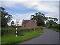
Wetheral Methodist Church
This small church stands to the west of the village. The foundation stone (beneath the large window) is inscribed: "This stone was laid by John Nicholson, April 15th 1873".
Image: © Richard Dorrell
Taken: 25 Jul 2011
0.10 miles
2
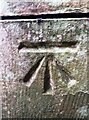
Benchmark on buttress of Wetheral Methodist Church
Ordnance Survey cut mark benchmark described on the Bench Mark Database at www.bench-marks.org.uk/bm137270
Image: © Roger Templeman
Taken: 13 Sep 2021
0.11 miles
3
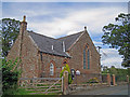
Wetheral Methodist Church
This small church stands to the west of the village. The foundation stone (beneath the large window) is inscribed: "This stone was laid by John Nicholson, April 15th 1873".
Image: © Richard Dorrell
Taken: 25 Jul 2011
0.12 miles
4
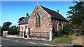
Wetheral Methodist Church
Ordnance Survey documents indicate that a benchmark levelled at 53.400m above Newlyn Datum was verified in 1972 on the back face of the buttress on the near corner of the church. See Image
Image: © Roger Templeman
Taken: 7 Sep 2021
0.12 miles
5
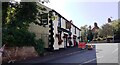
Road sign, seat and church, Wetheral
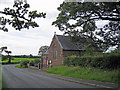
The location is a junction of unclassified roads just to the west of Wetheral village. Many of the junctions locally have black and white fingerpost signposts as seen here. Next to the sign is a wrought iron bench. The building is Wetheral Methodist Church.
Image: © Richard Dorrell
Taken: 25 Jul 2011
0.13 miles
6
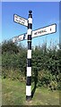
Cumberland County Council finger signpost on verge west of Wetheral Methodist Church
The signpost has Milestone Society National ID: CU_NY4654A
Image: © Roger Templeman
Taken: 7 Sep 2021
0.14 miles
7
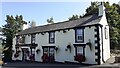
Roadworks outside The Wheatsheaf at bend in B6263
There is an Ordnance Survey benchmark Image on the near jamb of the pub's door under the pub sign
Image: © Roger Templeman
Taken: 7 Sep 2021
0.14 miles
8
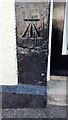
Benchmark on door jamb of The Wheatsheaf pub
Ordnance Survey cut mark benchmark described on the Bench Mark Database at www.bench-marks.org.uk/bm137290
Image: © Roger Templeman
Taken: 7 Sep 2021
0.14 miles
10
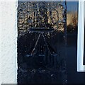
Benchmark, The Wheatsheaf Inn
Detail of the Ordnance Survey cut benchmark on the painted door jamb of the Wheatsheaf Inn in Wetheral. The benchmark marks a height of 63.268m above sea level (Ordnance Datum Newlyn) last verified in 1972 (location photograph Image).
Image: © Adrian Taylor
Taken: 11 Feb 2021
0.14 miles