IMAGES TAKEN NEAR TO
Ridge Close, CARLISLE, CA4 8FU
Introduction
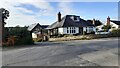
This page details the photographs taken nearby to Ridge Close, CA4 8FU by members of the Geograph project.
The Geograph project started in 2005 with the aim of publishing, organising and preserving representative images for every square kilometre of Great Britain, Ireland and the Isle of Man.

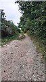
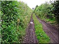
There are currently over 7.5m images from over14,400 individuals and you can help contribute to the project by visiting https://www.geograph.org.uk
Image Map
Images are licensed for reuse under creativecommons.org/licenses/by-sa/2.0
Notes
- Clicking on the map will re-center to the selected point.
- The higher the marker number, the further away the image location is from the centre of the postcode.
Image Listing (14 Images Found)
Images are licensed for reuse under creativecommons.org/licenses/by-sa/2.0
Image
Details
Distance
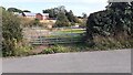
1
Junction of minor road from Broomfallen Road
Ordnance Survey documents indicate that a benchmark levelled at 46.146m above Newlyn Datum was verified in 1972 on a gatepost at the hedge junction at the left hand side of the junction
Image: © Roger Templeman
Taken: 16 Sep 2021
0.07 miles
2
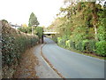
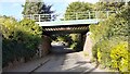
Railway Bridge
Railway bridge at Scotby which carries the Carlisle to Settle Railway over the Scotby to Cumwhinton road
Image: © Alexander P Kapp
Taken: 2 Nov 2006
0.09 miles
3
West end of Lady Steps seen from east side of Broomfallen Road
With entrance to 'Oakleigh' on the right
Image: © Luke Shaw
Taken: 16 Sep 2021
0.15 miles
4
Field gateway on SE side of minor road SW of Scotby
Ordnance Survey documents indicate that a benchmark levelled at 40.324m above Newlyn Datum was verified in 1972 on a gatepost at this location
Image: © Roger Templeman
Taken: 16 Sep 2021
0.16 miles
5
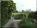
Bridleway to the Garlands
Taken from track to St Brelades and Lambley Bank, bridleway from Scotby to The Garlands which crosses the M6.
Image: © Rose and Trev Clough
Taken: 26 May 2007
0.18 miles
6
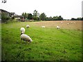
Sheep in a field behind Ghyll Road
Image: © Rose and Trev Clough
Taken: 20 Aug 2011
0.18 miles
7
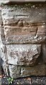
Benchmark on bridge taking railway over Broomfallen Road
Ordnance Survey cut mark benchmark levelled at 37.649m above Newlyn Datum verified 1972
Image: © Roger Templeman
Taken: 16 Sep 2021
0.19 miles
8
Public bridleway to Shiel Lonning
View from the end of Ghyll Road.
Image: © Rose and Trev Clough
Taken: 20 Aug 2011
0.19 miles
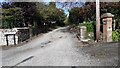
9
Bridge carrying Settle-Carlisle Railway over Broomfallen Road
There is an Ordnance Survey benchmark Image on the near end of the bridge wall at the left hand side of the road
Image: © Roger Templeman
Taken: 16 Sep 2021
0.20 miles