IMAGES TAKEN NEAR TO
Croft Close, CARLISLE, CA4 8FG
Introduction
This page details the photographs taken nearby to Croft Close, CA4 8FG by members of the Geograph project.
The Geograph project started in 2005 with the aim of publishing, organising and preserving representative images for every square kilometre of Great Britain, Ireland and the Isle of Man.

There are currently over 7.5m images from over14,400 individuals and you can help contribute to the project by visiting https://www.geograph.org.uk
Image Map (Loading...)


Getting Data...Please wait
Leaflet Map data © OpenStreetMap
Images are licensed for reuse under creativecommons.org/licenses/by-sa/2.0
Notes
- Clicking on the map will re-center to the selected point.
- The higher the marker number, the further away the image location is from the centre of the postcode.
Image Listing (23 Images Found)
Images are licensed for reuse under creativecommons.org/licenses/by-sa/2.0
Image
Details
Distance
1
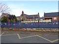
Cumwhinton Primary School
The railings are decorated with pennants, whilst inside the playground eight giant coloured crayons stand upright.
Image: © Oliver Dixon
Taken: 25 Oct 2016
0.07 miles
3
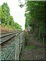
Footpath level crossing southeast of Cumwhinton
A footpath between Cumwhinton and Wetheral Shield crosses the Settle-Carlisle railway line. According to the ABC Railway Guide, this is called Pickies Quarry Level Crossing http://abcrailwayguide.uk/pickies-quarry-public-level-crossing-cumbria#.V76IvqLcCxv .
Image: © Rose and Trev Clough
Taken: 28 May 2006
0.15 miles
4
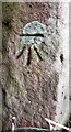
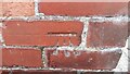
Benchmark on gatepost at field gateway on SW side of Peter Gate
Ordnance Survey cut mark benchmark levelled at 71.395m above Newlyn Datum verified 1972
Image: © Roger Templeman
Taken: 9 Sep 2021
0.16 miles
5
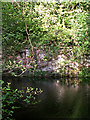
Pond, Quarry Banks Nature Reserve, 2006
The reserve is owned by Cumbria Wildlife Trust http://www.cumbriawildlifetrust.org.uk/reserves/quarry-banks . It occupies 1.8 ha between the Pow Maughan Beck and the Settle-Carlisle railway line. The area was previously quarried for sandstone used to construct the railway, and flooding of the abandoned workings created this pond.
Image: © Rose and Trev Clough
Taken: 28 May 2006
0.17 miles
6
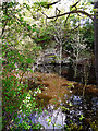
Pond, Quarry Banks Nature Reserve, 2016
The reserve is owned by Cumbria Wildlife Trust http://www.cumbriawildlifetrust.org.uk/reserves/quarry-banks . The pond was created by partial flooding of a disused quarry. The sandstone was used in construction of the Settle-Carlisle railway, a stretch of which forms the eastern boundary of the reserve.
There is not much aquatic vegetation in the pond, because it is shaded by the surrounding woodland. However, there are plenty of tree saplings emerging from the water. We got the impression that these had increased in number since we visited the site 10 years previously (see photo taken 2006 Image ).
Image: © Rose and Trev Clough
Taken: 23 May 2016
0.17 miles
7
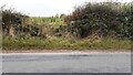
Field gateway on SW side of Peter Gate
There is an Ordnance Survey benchmark Image on the inside face of the right hand gatepost which is located in the hedge
Image: © Roger Templeman
Taken: 9 Sep 2021
0.17 miles
8
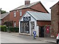
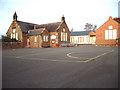
The Old Village Shop
Cumwhinton Post Office.
Image: © Richard Webb
Taken: 28 Jun 2014
0.18 miles
9
Benchmark on Orchard View on SE side of B6263
Ordnance Survey cut mark benchmark levelled at 63.426m above Newlyn Datum verified 1972
Image: © Roger Templeman
Taken: 7 Sep 2021
0.18 miles
10
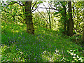
Woodland, Quarry Banks Nature Reserve
The reserve slopes down from the Settle-Carlisle railway line on its eastern boundary, towards Pow Maughan Beck. Sandstone was quarried here in the 19th century for construction of the railway. In 1987 the land was donated by British Rail to the Cumbria Wildlife Trust http://www.cumbriawildlifetrust.org.uk/reserves/quarry-banks .
Quarry Banks is dedicated to the memory of Allan Wilson, a former education adviser and Trust committee member.
Image: © Rose and Trev Clough
Taken: 23 May 2016
0.18 miles