IMAGES TAKEN NEAR TO
Scotby, CARLISLE, CA4 8EF
Introduction
This page details the photographs taken nearby to CA4 8EF by members of the Geograph project.
The Geograph project started in 2005 with the aim of publishing, organising and preserving representative images for every square kilometre of Great Britain, Ireland and the Isle of Man.

There are currently over 7.5m images from over14,400 individuals and you can help contribute to the project by visiting https://www.geograph.org.uk
Image Map
Images are licensed for reuse under creativecommons.org/licenses/by-sa/2.0
Notes
- Clicking on the map will re-center to the selected point.
- The higher the marker number, the further away the image location is from the centre of the postcode.
Image Listing (54 Images Found)
Images are licensed for reuse under creativecommons.org/licenses/by-sa/2.0
Image
Details
Distance

2
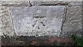
Benchmark on SW wing wall of railway bridge NEC2-160
Ordnance Survey cut mark benchmark levelled at 32.165m above Newlyn Datum verified 1972
Image: © Roger Templeman
Taken: 16 Sep 2021
0.13 miles
3
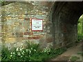
Bridge NEC2/160, Newcastle-Carlisle Railway
A public footpath/farm track cuts through the railway embankment (wider view here http://www.geograph.org.uk/photo/2622935 ).
The notice tells who to contact in the event of a vehicle striking the bridge.
Image: © Rose and Trev Clough
Taken: 27 May 2007
0.13 miles
4
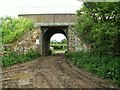
Railway bridge over public footpath
The path starts from the Scotby to Wetheral road (seen through bridge) and ends near Warwick-on-Eden (see Image ).
A closer look at the bridge here Image .
Image: © Rose and Trev Clough
Taken: 27 May 2007
0.13 miles
5
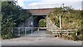
Bridge NEC2-160 taking Carlisle to Newcastle railway over farmland access track
There is an Ordnance Survey benchmark Image on the bridge wing wall on the left hand side of the track/footpath
Image: © Roger Templeman
Taken: 16 Sep 2021
0.14 miles
6
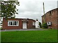
Scotby Village Hall
The building extends quite a way back, the main hall has a capacity for 150 people (Village Hall website http://www.wetheralvillagehalls.org.uk/scotby.php ).
You find some quality stuff at the jumble sales here, a good indicator of local prosperity.
Image: © Rose and Trev Clough
Taken: 20 Aug 2011
0.14 miles
7
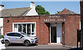
Site of "Welcome Inn", Scotby - May 2017
Acquired by the State Management Scheme in 1916, the "Welcome Inn" was closed on 21 November 1916. It appears to have been then demolished, as Scotby Village Hall (built on the site) dates from 1926 with an extension added in 1953. According to period OS Maps, the hall was called the "Welcome Institute" from 1926 until circa 1968.
Image: © The Carlisle Kid
Taken: 25 May 2017
0.14 miles
8
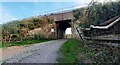
Railway bridge over footpath/farmland access track at east side of Scotby
The roofs of a Class 158 dmu on a Carlisle to Newcastle service can be seen crossing the bridge Image
Image: © Roger Templeman
Taken: 16 Sep 2021
0.14 miles
9
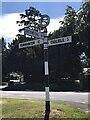
Direction Sign ? Signpost in Scotby, Wetheral parish
Located in Scotby on the southeast side of a T junction on Scotby Road, Wetheral parish. 3 arms and annulus finial.
Milestone Society National ID: CU_NY4455A
Image: © J Kelly
Taken: Unknown
0.14 miles