IMAGES TAKEN NEAR TO
Low Croft, CARLISLE, CA4 8DZ
Introduction
This page details the photographs taken nearby to Low Croft, CA4 8DZ by members of the Geograph project.
The Geograph project started in 2005 with the aim of publishing, organising and preserving representative images for every square kilometre of Great Britain, Ireland and the Isle of Man.

There are currently over 7.5m images from over14,400 individuals and you can help contribute to the project by visiting https://www.geograph.org.uk
Image Map
Images are licensed for reuse under creativecommons.org/licenses/by-sa/2.0
Notes
- Clicking on the map will re-center to the selected point.
- The higher the marker number, the further away the image location is from the centre of the postcode.
Image Listing (28 Images Found)
Images are licensed for reuse under creativecommons.org/licenses/by-sa/2.0
Image
Details
Distance
1
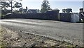
NW parapet of bridge taking B6263 over Settle-Carlisle Railway
There is an Ordnance Survey flush bracket Image on the side of the near parapet pier
Image: © Roger Templeman
Taken: 7 Sep 2021
0.04 miles
2
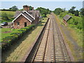
Cumwhinton station
This former station building on the Carlisle - Settle line is now a private residence (belonging to my wife's uncle)
Image: © Brian Norman
Taken: 21 Sep 2006
0.04 miles
3
B6263 road bridge over Settle to Carlisle railway line at Cumwhinton
The line was built between 1870 and 1876 and this 1875 Grade II Listed road bridge was engineered by J S Crossley. According to Nigel Mussett's directory of resources for the line this is bridge 346 at 304 miles 9 chains (489.422051 km) from St Pancras. The top of the Grade II Listed station masters house is just visible on the right.
Image: © Jo and Steve Turner
Taken: 10 Jun 2023
0.04 miles
4
Cumwhinton Station, B6263 Station Road, Cumwhinton
Grade II Listed 1875 railway station on the Settle to Carlisle line. The line was built between 1870 and 1876 and fully opened along with this station on 1st May 1876. It was designed by John Holloway Sanders, who designed many of the other stations on the line. The station closed to goods and passengers on 5th November 1956 and is now a private house named The Station. The station is 304 miles, 12 chains (489.4824 km) from St Pancras. It had a three-road goods shed on the down side. The signal box opened August 1875, replaced 1897, and was closed February 1957 and subsequently demolished. The Stationmasters house and four railway cottages still extant are up the slope behind the station, also Grade II Listed. Stationmasters were; John Lambert 1876 - 1877 (taken into custody 3/10/1877); William J. Stowell 1878 - 1886; G. Barker 1886 - 1891; Isaac Scott 1891 - 1915; W.S. Balfour from 1915; J.H. Ashton from 1945.
Image: © Jo and Steve Turner
Taken: 10 Jun 2023
0.05 miles
5
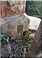
Benchmark on NE end of NW parapet of B6263 railway bridge
Ordnance Survey flush bracket (serial number 1359) benchmark described on the Bench Mark Database at www.bench-marks.org.uk/bm2442
Image: © Roger Templeman
Taken: 7 Sep 2021
0.05 miles
6
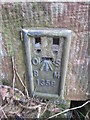
Ordnance Survey Flush Bracket (1359)
This OS Flush Bracket can be found on the end of the north parapet of the railway bridge. It marks a point 62.7044m above mean sea level.
Image: © Adrian Dust
Taken: 11 Apr 2016
0.05 miles
7
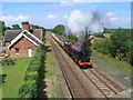
Cumwhinton Station (as was)
Cumwhinton Station on the Settle to Carlisle railway was opened in 1875, but closed to passengers in 1956. The main station building is now converted to a private residence. Both the station house and the shelter on the opposite platform are Grade 2 listed.
For most of this year, this section of the line between Armathwaite and Carlisle has been closed following a huge landslip where the line has been undercut by the River Eden. Re-opening is scheduled for spring 2017.
Image: © Oliver Dixon
Taken: 25 Oct 2016
0.05 miles
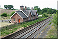
8
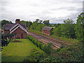
Cumwhinton Station
The railway is still in use, but this station is long-since closed, and the station house is now a private dwelling.
Image: © Richard Dorrell
Taken: 25 Jul 2011
0.05 miles
9
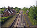
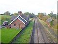
Railway to Carlisle, Cumwhinton
Looking along the line from the B6263 road bridge over the long-since closed station at Cumwhinton.
Image: © Richard Dorrell
Taken: 25 Jul 2011
0.06 miles
10
Cumwhinton railway station (site), Cumbria
Opened in 1876 by the Midland Railway on the line from Settle to Carlisle, this station closed in 1956. View north west towards Scotby and Carlisle.
Image: © Nigel Thompson
Taken: 14 Jul 2013
0.06 miles