IMAGES TAKEN NEAR TO
Aglionby, CARLISLE, CA4 8AW
Introduction
This page details the photographs taken nearby to CA4 8AW by members of the Geograph project.
The Geograph project started in 2005 with the aim of publishing, organising and preserving representative images for every square kilometre of Great Britain, Ireland and the Isle of Man.

There are currently over 7.5m images from over14,400 individuals and you can help contribute to the project by visiting https://www.geograph.org.uk
Image Map
Images are licensed for reuse under creativecommons.org/licenses/by-sa/2.0
Notes
- Clicking on the map will re-center to the selected point.
- The higher the marker number, the further away the image location is from the centre of the postcode.
Image Listing (8 Images Found)
Images are licensed for reuse under creativecommons.org/licenses/by-sa/2.0
Image
Details
Distance
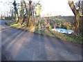
1
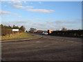
Turning for Aglionby
A view looking to the east along the A69 at the junction with the lane to Aglionby.
Image: © Phil Williams
Taken: 17 Feb 2007
0.14 miles
5
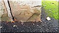
Benchmark on gatepost at entrance to Hill House Barn
Ordnance Survey cut mark benchmark not documented in OS records
Image: © Roger Templeman
Taken: 1 Nov 2022
0.20 miles
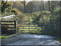
6
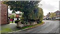
Bend in road outside Hill House Barn
There is an Ordnance Survey benchmark Image on the stone gatepost at the near end of the roadside wall at the entrance
Image: © Roger Templeman
Taken: 1 Nov 2022
0.21 miles
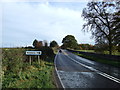
7
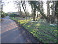
Snowdrops at Aglionby
A view looking to the southwest along the lane through Aglionby, towards a clump of snowdrops illuminated by the late afternoon sun.
Image: © Phil Williams
Taken: 17 Feb 2007
0.24 miles
8
Pond at Aglionby
A view looking to the northeast across the lane through Aglionby towards a small pond.
Image: © Phil Williams
Taken: 17 Feb 2007
0.24 miles