IMAGES TAKEN NEAR TO
Park Road, CARLISLE, CA4 8AR
Introduction
This page details the photographs taken nearby to Park Road, CA4 8AR by members of the Geograph project.
The Geograph project started in 2005 with the aim of publishing, organising and preserving representative images for every square kilometre of Great Britain, Ireland and the Isle of Man.

There are currently over 7.5m images from over14,400 individuals and you can help contribute to the project by visiting https://www.geograph.org.uk
Image Map
Images are licensed for reuse under creativecommons.org/licenses/by-sa/2.0
Notes
- Clicking on the map will re-center to the selected point.
- The higher the marker number, the further away the image location is from the centre of the postcode.
Image Listing (22 Images Found)
Images are licensed for reuse under creativecommons.org/licenses/by-sa/2.0
Image
Details
Distance
1

The Park and scarecrow on south side of Park Road
There is an Ordnance Survey benchmark Image on the inside face of the left hand gatepost at the entrance to the houses
Image: © Roger Templeman
Taken: 25 Sep 2021
0.02 miles
2
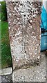
Benchmark on gatepost next to 'The Park' on south side of Park Road
Ordnance Survey cut mark benchmark described on the Bench Mark Database at www.bench-marks.org.uk/bm119394
Image: © Roger Templeman
Taken: 25 Sep 2021
0.03 miles
3
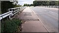
Scotby Bridge taking Park Road over M6
Ordnance Survey records indicate that a benchmark levelled at 32.818m above Newlyn Datum was verified in 1972 on the base of the bridge parapet at its near end. See www.bench-marks.org.uk/bm119392
Image: © Roger Templeman
Taken: 25 Sep 2021
0.10 miles
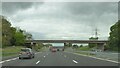
4
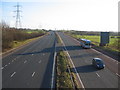
The M6 south of junction 43
A view looking to the south along the M6 from the overbridge to the south of junction 43.
Image: © Phil Williams
Taken: 17 Feb 2007
0.10 miles
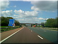
5
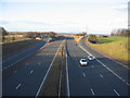
M6 Junction 43
A view looking north along the M6 motorway towards junction 43.
Image: © Phil Williams
Taken: 17 Feb 2007
0.10 miles
6
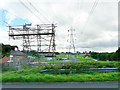
Power line upgrade in progress
Part of a £30 million project by National Grid, to repair steelwork and replace wires, on an electricity transmission line which runs across Cumbria and Lancashire http://www.nationalgrid.com/uk/Media+Centre/PressReleases/2013/National+Grid+starts+second+phase+of+%a330m+project+to+secure+energy+supplies+06.08.13.htm .
Trackways have been laid in the field to facilitate access. Where the line crosses roads, railways, rivers etc, scaffolding is erected with safety netting strung across, as seen here on Park Road, Scotby.
Image: © Rose and Trev Clough
Taken: 18 Sep 2013
0.11 miles
7

Approaching Junction 43 heading north
M6 motorway
Image: © John Firth
Taken: 9 May 2012
0.13 miles
10

City of Carlisle : The M6 Motorway
Looking north along the M6 Motorway.
Image: © Lewis Clarke
Taken: 22 Apr 2016
0.13 miles