IMAGES TAKEN NEAR TO
Wheelbarrow Court, CARLISLE, CA4 8AB
Introduction
This page details the photographs taken nearby to Wheelbarrow Court, CA4 8AB by members of the Geograph project.
The Geograph project started in 2005 with the aim of publishing, organising and preserving representative images for every square kilometre of Great Britain, Ireland and the Isle of Man.

There are currently over 7.5m images from over14,400 individuals and you can help contribute to the project by visiting https://www.geograph.org.uk
Image Map
Images are licensed for reuse under creativecommons.org/licenses/by-sa/2.0
Notes
- Clicking on the map will re-center to the selected point.
- The higher the marker number, the further away the image location is from the centre of the postcode.
Image Listing (14 Images Found)
Images are licensed for reuse under creativecommons.org/licenses/by-sa/2.0
Image
Details
Distance
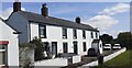
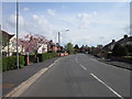
1
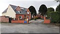
Cottages by the A69
Neat cottages facing the busy A69 near Aglionby. They stand on the junction with Holme Lane.
Image: © Richard Dorrell
Taken: 25 Jul 2011
0.02 miles
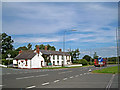
2
Nos. 1, 2 & 3 Holme Park on north side of A69 at Holme Lane junction
Image: © Luke Shaw
Taken: 16 Jul 2022
0.05 miles
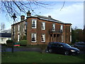
4
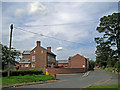
Wheelbarrow Hall
A Grade 2 listed building, used in the 18th century as the parish workhouse. The house is currently in use as a children's day nursery.
Image: © Richard Dorrell
Taken: 25 Jul 2011
0.09 miles
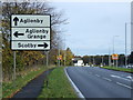
8
Aglionby Grange on east side of Holme Lane
Image: © Roger Templeman
Taken: 25 Sep 2021
0.18 miles
9
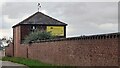
Building with weather vane (and crow) on east side of Holme Lane
Image: © Luke Shaw
Taken: 25 Sep 2021
0.20 miles