IMAGES TAKEN NEAR TO
High Woodbank, CARLISLE, CA4 0QR
Introduction
This page details the photographs taken nearby to High Woodbank, CA4 0QR by members of the Geograph project.
The Geograph project started in 2005 with the aim of publishing, organising and preserving representative images for every square kilometre of Great Britain, Ireland and the Isle of Man.

There are currently over 7.5m images from over14,400 individuals and you can help contribute to the project by visiting https://www.geograph.org.uk
Image Map (Loading...)


Getting Data...Please wait
Leaflet Map data © OpenStreetMap
Images are licensed for reuse under creativecommons.org/licenses/by-sa/2.0
Notes
- Clicking on the map will re-center to the selected point.
- The higher the marker number, the further away the image location is from the centre of the postcode.
Image Listing (6 Images Found)
Images are licensed for reuse under creativecommons.org/licenses/by-sa/2.0
Image
Details
Distance
1
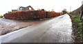
Brisco Road heading SE at High Woodbank houses
There is an Ordnance Survey benchmark Image on the roadside wall in front of House #5
Image: © Roger Templeman
Taken: 18 Nov 2021
0.01 miles
2
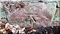
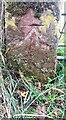
Benchmark on wall on NE side of Brisco Road at High Woodbank
Ordnance Survey cut mark benchmark levelled at 49.722m above Newlyn Datum verified 1972
Image: © Roger Templeman
Taken: 18 Nov 2021
0.02 miles
3
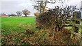
Field on NE side Brisco Road SE of High Woodbank houses
Image: © Luke Shaw
Taken: 18 Nov 2021
0.04 miles
5
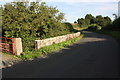
Benchmark on gatepost at field gateway on SW side of Brisco Road NW of Brisco Hall
Ordnance Survey cut mark benchmark levelled at 59.729m above Newlyn Datum verified 1972
Image: © Roger Templeman
Taken: 18 Nov 2021
0.22 miles
6
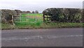
Field gateway on SW side of Brisco Road NW of Brisco Farm
There is an Ordnance Survey benchmark Image on the inside face of the left hand gatepost of the gateway
Image: © Roger Templeman
Taken: 18 Nov 2021
0.22 miles