IMAGES TAKEN NEAR TO
Front Street, CARLISLE, CA4 0DZ
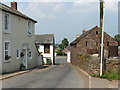
Introduction
This page details the photographs taken nearby to Front Street, CA4 0DZ by members of the Geograph project.
The Geograph project started in 2005 with the aim of publishing, organising and preserving representative images for every square kilometre of Great Britain, Ireland and the Isle of Man.

There are currently over 7.5m images from over14,400 individuals and you can help contribute to the project by visiting https://www.geograph.org.uk
Image Map
Images are licensed for reuse under creativecommons.org/licenses/by-sa/2.0
Notes
- Clicking on the map will re-center to the selected point.
- The higher the marker number, the further away the image location is from the centre of the postcode.
Image Listing (34 Images Found)
Images are licensed for reuse under creativecommons.org/licenses/by-sa/2.0
Image
Details
Distance
1
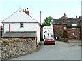
Bus going through the Narrows at Cotehill
The same tight gap viewed from the other direction, here Image .
Image: © Rose and Trev Clough
Taken: 18 Sep 2013
0.01 miles
2

Cotehill
As you would expect from the name, it's a bit of a haul up into the village.
Image: © Richard Webb
Taken: 28 Jun 2014
0.01 miles
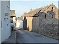
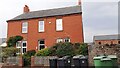
3
Old red sandstone buildings in Back Street
Image: © Rose and Trev Clough
Taken: 18 Sep 2013
0.01 miles
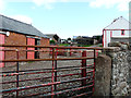
4
Road narrows!
A sudden narrowing of Peter Gate, the principal south-north thoroughfare through the village of Cotehill, where the road squeezes between farm buildings.
Image: © Oliver Dixon
Taken: 25 Oct 2016
0.02 miles
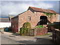
5
Cobbled farmyard
At Chapel Farm, Cotehill.
Image: © Rose and Trev Clough
Taken: 18 Sep 2013
0.04 miles
6
Cotehill
A narrow gap on the road to Cumwhinton.
Image: © Andrew Smith
Taken: 2 Jul 2006
0.04 miles
7

Junction in Cotehill village
Turn left for Cumwhinton and Carlisle, right for Armathwaite.
Image: © Mary and Angus Hogg
Taken: 27 Sep 2022
0.05 miles
8
Croft House on east side of Peter Gate
There is an Ordnance Survey benchmark Image on the left hand end of the wall right of the house, seen through gap between black and green wheelie bins
Image: © Roger Templeman
Taken: 9 Sep 2021
0.05 miles
9
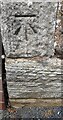
Benchmark on wall on south side of Croft House, east side of Peter Gate
Ordnance Survey cut mark benchmark levelled at 91.611m above Newlyn Datum verified 1972
Image: © Roger Templeman
Taken: 9 Sep 2021
0.05 miles
10
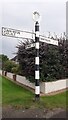
Cumberland County Council finger signpost at Cotehill crossroads
The signpost has Milestone Society National ID: CU_NY4650B
Image: © Roger Templeman
Taken: 9 Sep 2021
0.06 miles