IMAGES TAKEN NEAR TO
Cumwhinton, CARLISLE, CA4 0AP
Introduction
This page details the photographs taken nearby to CA4 0AP by members of the Geograph project.
The Geograph project started in 2005 with the aim of publishing, organising and preserving representative images for every square kilometre of Great Britain, Ireland and the Isle of Man.

There are currently over 7.5m images from over14,400 individuals and you can help contribute to the project by visiting https://www.geograph.org.uk
Image Map
Images are licensed for reuse under creativecommons.org/licenses/by-sa/2.0
Notes
- Clicking on the map will re-center to the selected point.
- The higher the marker number, the further away the image location is from the centre of the postcode.
Image Listing (7 Images Found)
Images are licensed for reuse under creativecommons.org/licenses/by-sa/2.0
Image
Details
Distance
1
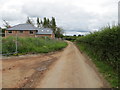
Minor road and new housing at Stripes
Looking south-eastward.
Image: © Peter Wood
Taken: 11 Jul 2020
0.04 miles
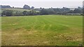
3
Crows gleaning in a recently harvested field
At Stripes. The Settle to Carlisle railway runs at the far side of the next field.
Image: © Oliver Dixon
Taken: 25 Oct 2016
0.12 miles
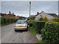
4
Mown field on NE side of Peter Gate at Stripes
Image: © Roger Templeman
Taken: 9 Sep 2021
0.14 miles
5

Bridleway, Stripes
The bridleway takes riders and walkers from Stripes to Cocklakes.
Image: © Maigheach-gheal
Taken: 5 Apr 2010
0.16 miles
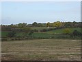
6
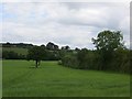
Field, Stripes
An odd bit of arable land.
Image: © Richard Webb
Taken: 28 Jun 2014
0.21 miles
7
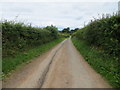
Hedge-lined minor road heading towards Cumwhinton
Looking north-westward.
Image: © Peter Wood
Taken: 11 Jul 2020
0.25 miles