IMAGES TAKEN NEAR TO
Carleton, CARLISLE, CA4 0AH
Introduction
This page details the photographs taken nearby to CA4 0AH by members of the Geograph project.
The Geograph project started in 2005 with the aim of publishing, organising and preserving representative images for every square kilometre of Great Britain, Ireland and the Isle of Man.

There are currently over 7.5m images from over14,400 individuals and you can help contribute to the project by visiting https://www.geograph.org.uk
Image Map
Images are licensed for reuse under creativecommons.org/licenses/by-sa/2.0
Notes
- Clicking on the map will re-center to the selected point.
- The higher the marker number, the further away the image location is from the centre of the postcode.
Image Listing (47 Images Found)
Images are licensed for reuse under creativecommons.org/licenses/by-sa/2.0
Image
Details
Distance
1
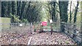
Change of plan needed
Footpath closed because of danger of landslip
Image: © Roger Templeman
Taken: 1 Nov 2021
0.05 miles
2
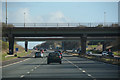
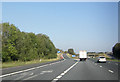
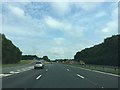
City of Carlisle : The M6 Motorway
Heading towards junction 42 of the M6 Motorway.
Image: © Lewis Clarke
Taken: 22 Apr 2016
0.06 miles
3
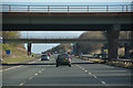
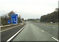
City of Carlisle : The M6 Motorway
Heading underneath bridges carrying junction 42.
Image: © Lewis Clarke
Taken: 22 Apr 2016
0.07 miles
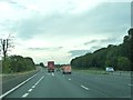
10
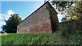
Building at Golden Fleece opposite service station
There is an Ordnance Survey benchmark Image on the near corner, right hand face, of the building
Image: © Roger Templeman
Taken: 16 Sep 2021
0.11 miles