IMAGES TAKEN NEAR TO
Rickerby, CARLISLE, CA3 9AA
Introduction
This page details the photographs taken nearby to CA3 9AA by members of the Geograph project.
The Geograph project started in 2005 with the aim of publishing, organising and preserving representative images for every square kilometre of Great Britain, Ireland and the Isle of Man.

There are currently over 7.5m images from over14,400 individuals and you can help contribute to the project by visiting https://www.geograph.org.uk
Image Map
Images are licensed for reuse under creativecommons.org/licenses/by-sa/2.0
Notes
- Clicking on the map will re-center to the selected point.
- The higher the marker number, the further away the image location is from the centre of the postcode.
Image Listing (42 Images Found)
Images are licensed for reuse under creativecommons.org/licenses/by-sa/2.0
Image
Details
Distance
1
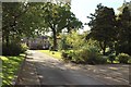
Drive to Rickerby Hall
The private drive to the big house of Rickerby Hall.
Image: © Graham Robson
Taken: 6 Oct 2018
0.02 miles
2
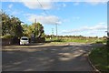
Road junction, Rickerby
The main entrance into Rickerby from the road between Carlisle and Linstock.
Image: © Graham Robson
Taken: 6 Oct 2018
0.02 miles
3
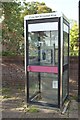
Phonebox in Rickerby
The public phone box in the small village of Rickerby. It is located close to the junction of the access into Rickerby with the lane between Rickerby and Linstock. Image is a slightly wider view including the adjacent postbox.
Image: © Graham Robson
Taken: 6 Oct 2018
0.02 miles
4
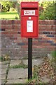
Postbox in Rickerby
A postbox in Rickerby standing at the junction with the lane between Rickerby and Linstock. Image shows the postbox in its location next to the village phone box.
Image: © Graham Robson
Taken: 6 Oct 2018
0.03 miles
5

Communication in Rickerby
A public phone box and post box at the road junction in Rickerby.
Image: © Graham Robson
Taken: 6 Oct 2018
0.03 miles

7

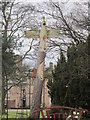
In the grounds of Rickerby House
Seen from the Hadrian's Wall Path.
Image: © David Purchase
Taken: 31 May 2013
0.03 miles
8
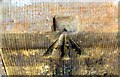
Benchmark on old boys' school in Rickerby
Ordnance Survey pivot benchmark levelled at 17.483m above Newlyn Datum
Image: © Roger Templeman
Taken: 16 Sep 2019
0.03 miles
10
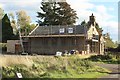
Former school, Rickerby
An old school building in Rickerby. The building dates from 1835. Image shows the building from a closer and different angle. The listing text at https://historicengland.org.uk/listing/the-list/list-entry/1335509 suggests the building hasn't been used as a school for well over a century.
Image: © Graham Robson
Taken: 6 Oct 2018
0.04 miles