IMAGES TAKEN NEAR TO
Brampton Old Road, CARLISLE, CA3 0JN
Introduction
This page details the photographs taken nearby to Brampton Old Road, CA3 0JN by members of the Geograph project.
The Geograph project started in 2005 with the aim of publishing, organising and preserving representative images for every square kilometre of Great Britain, Ireland and the Isle of Man.

There are currently over 7.5m images from over14,400 individuals and you can help contribute to the project by visiting https://www.geograph.org.uk
Image Map
Images are licensed for reuse under creativecommons.org/licenses/by-sa/2.0
Notes
- Clicking on the map will re-center to the selected point.
- The higher the marker number, the further away the image location is from the centre of the postcode.
Image Listing (35 Images Found)
Images are licensed for reuse under creativecommons.org/licenses/by-sa/2.0
Image
Details
Distance
2
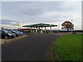
Petrol station, Brampton Old Road, Carlisle
A BP branded fuel filling station on Brampton Old Road at its junction with Houghton Road.
Image: © Graham Robson
Taken: 6 Oct 2018
0.02 miles
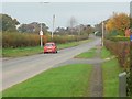
3

Bus shelter, east side, Houghton Road
For passengers heading south, into Carlisle. Northbound passengers have nothing to protect them.
Image: © Christine Johnstone
Taken: 2 Nov 2015
0.03 miles
4
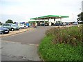
Filling station at the junction of Houghton Road and Old Brampton Road, Carlisle
Image: © Oliver Dixon
Taken: 24 Sep 2006
0.04 miles
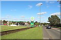
5
Houghton Road, on the edge of Carlisle
Crossing the route of Hadrian's Wall at the distant bend.
Image: © Christine Johnstone
Taken: 2 Nov 2015
0.05 miles
6
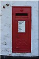
Postbox, Whiteclosegate, Carlisle
A postbox in the wall of the Near Boot pub on the northern side of Whiteclosegate on the eastern edge of Carlisle. The roadside façade of the pub containing the post box can be seen in Image
Image: © Graham Robson
Taken: 6 Oct 2018
0.07 miles
7
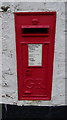
George V postbox on Whiteclosegate, Carlisle
Postbox No. CA3 93.
See Image] for context.
Image: © JThomas
Taken: 20 Nov 2019
0.07 miles
8
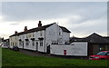
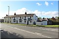
The Near Boot, Carlisle
On Whiteclosegate.
Showing position of Postbox No. CA3 93.
See Image] for postbox.
Image: © JThomas
Taken: 20 Nov 2019
0.07 miles
9
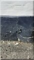
Datum cut of benchmark on Near Boot Inn
Remains of Ordnance Survey cut mark benchmark levelled at 29.657m above Newlyn Datum and verified in 1972
Image: © Luke Shaw
Taken: 16 Apr 2021
0.07 miles
10
The Near Boot, Whiteclosegate, Carlisle
An unusually named pub, the Near Boot, on the eastern edge of Carlisle.
Image: © Graham Robson
Taken: 6 Oct 2018
0.07 miles