IMAGES TAKEN NEAR TO
Centurions Walk, CARLISLE, CA3 0JL
Introduction
This page details the photographs taken nearby to Centurions Walk, CA3 0JL by members of the Geograph project.
The Geograph project started in 2005 with the aim of publishing, organising and preserving representative images for every square kilometre of Great Britain, Ireland and the Isle of Man.

There are currently over 7.5m images from over14,400 individuals and you can help contribute to the project by visiting https://www.geograph.org.uk
Image Map
Images are licensed for reuse under creativecommons.org/licenses/by-sa/2.0
Notes
- Clicking on the map will re-center to the selected point.
- The higher the marker number, the further away the image location is from the centre of the postcode.
Image Listing (15 Images Found)
Images are licensed for reuse under creativecommons.org/licenses/by-sa/2.0
Image
Details
Distance
1
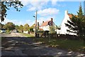
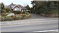
Centurions Walk, Carlisle
A small residential area off Old Brampton Road on the eastern fringe of Carlisle.
Image: © Graham Robson
Taken: 6 Oct 2018
0.06 miles
2
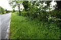
Brompton Old Road heading NE
There should be a milestone here!
Image: © Roger Templeman
Taken: 31 May 2019
0.07 miles
3
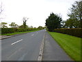
Whiteclosegate, B6264
Formerly A689, from Carlisle to Brampton. http://www.sabre-roads.org.uk/wiki/index.php?title=A689
Image: © Mike Faherty
Taken: 15 May 2012
0.07 miles
4

Whiteclosegate, Hadrians Park
Caravan park on Brampton Old Road.
Image: © Mike Faherty
Taken: 15 May 2012
0.10 miles
5
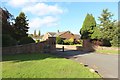
Entrance to Hadrian's Park, Carlisle
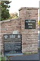
Hadrian's Park is a privately run residential site for travellers on the eastern edge of Carlisle. The site is built on what was once Hadrian's Camp, a former army apprentices school between 1959 and 1969, as explained on the memorial by the left hand gate post Image
Image: © Graham Robson
Taken: 6 Oct 2018
0.10 miles
6
Signs at entrance to Hadrian's Park
Hadrian's Park is a privately owned residential site for travellers on the eastern edge of Carlisle. The memorial tablet which explains part of the site's prior history as a home of an Army Apprentice School between 1959 and 69. Text on the memorial states that it was erected in 2013 by members of Hadrian's Old Boys Association. The wider context of the gate can be seen in Image
Image: © Graham Robson
Taken: 6 Oct 2018
0.10 miles
7
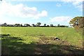
Field off Brampton Old Road, Carlisle
A grass field on the side of Brampton Old Road on the eastern edge of Carlisle.
Image: © Graham Robson
Taken: 6 Oct 2018
0.11 miles
8
No. 42 Houghton Road
There is an Ordnance Survey benchmark Image on the gatepost set into the wall at the right hand side of the house entrance drive
Image: © Luke Shaw
Taken: 16 Apr 2021
0.19 miles
9
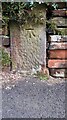
Benchmark on gatepost at entrance to No. 42 Houghton Road
Ordnance Survey cut mark benchmark levelled at 30.146m above Newlyn Datum verified in 1972
Image: © Luke Shaw
Taken: 16 Apr 2021
0.20 miles
10
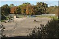
Hard standing, Hadrian's Park, Carlisle
A large unused area of concrete, part of Hadrian's Park travellers site. The northbound carriageway of the M6 motorway is behind the trees on the right edge of the photo.
Image: © Graham Robson
Taken: 6 Oct 2018
0.20 miles