IMAGES TAKEN NEAR TO
Cooper Way, CARLISLE, CA3 0JF
Introduction
This page details the photographs taken nearby to Cooper Way, CA3 0JF by members of the Geograph project.
The Geograph project started in 2005 with the aim of publishing, organising and preserving representative images for every square kilometre of Great Britain, Ireland and the Isle of Man.

There are currently over 7.5m images from over14,400 individuals and you can help contribute to the project by visiting https://www.geograph.org.uk
Image Map
Images are licensed for reuse under creativecommons.org/licenses/by-sa/2.0
Notes
- Clicking on the map will re-center to the selected point.
- The higher the marker number, the further away the image location is from the centre of the postcode.
Image Listing (26 Images Found)
Images are licensed for reuse under creativecommons.org/licenses/by-sa/2.0
Image
Details
Distance
4
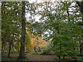
Woodland, Kingmoor (North) Nature Reserve
Mixed deciduous wood, for information see Image
Image: © Rose and Trev Clough
Taken: 5 Nov 2008
0.12 miles
5
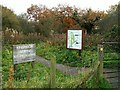
Entrance to Kingmoor (North) Nature Reserve
Kingmoor is the oldest nature reserve in Cumbria, established in 1914. It was once a continuous strip of woodland over 2km long. The central section was felled in 1933 to build an airfield, which later became the Kingstown Industrial Estate. The remaining north and south reserves are today connected by a footpath which follows the route of the dismantled Waverley Railway Line. The reserve is managed by Carlisle City Council. (Information in this description taken from the board shown in the photo).
Image: © Rose and Trev Clough
Taken: 12 Nov 2008
0.14 miles
7
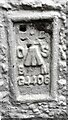
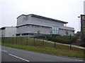
Benchmark on Park House Hotel
Ordnance Survey flush bracket (serial identifier G4406) benchmark described on the Bench Mark Database at www.bench-marks.org.uk/bm18635
Image: © Roger Templeman
Taken: 17 Aug 2021
0.16 miles
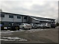
9
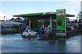
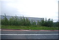
Asda Carlisle - petrol station
Petrol is offered by all the major supermarket chains at their larger out-of-town branches, usually at competitive prices - probably as a loss leader in most cases. This is the facility associated with Asda's store on the northern outskirts of Carlisle.
Image: © Stephen McKay
Taken: 4 Oct 2014
0.16 miles
10
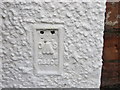
Ordnance Survey Flush Bracket G4406
This can be found on the wall of a building at the Gallo Rosso Restaurant at Parkhouse.
For more detail see : http://www.bench-marks.org.uk/bm16635
Image: © Peter Wood
Taken: 27 Sep 2014
0.16 miles