IMAGES TAKEN NEAR TO
Oswine Place, CARLISLE, CA3 0FZ
Introduction
This page details the photographs taken nearby to Oswine Place, CA3 0FZ by members of the Geograph project.
The Geograph project started in 2005 with the aim of publishing, organising and preserving representative images for every square kilometre of Great Britain, Ireland and the Isle of Man.

There are currently over 7.5m images from over14,400 individuals and you can help contribute to the project by visiting https://www.geograph.org.uk
Image Map
Images are licensed for reuse under creativecommons.org/licenses/by-sa/2.0
Notes
- Clicking on the map will re-center to the selected point.
- The higher the marker number, the further away the image location is from the centre of the postcode.
Image Listing (29 Images Found)
Images are licensed for reuse under creativecommons.org/licenses/by-sa/2.0
Image
Details
Distance
7
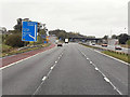
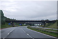
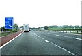
M6 Greymoorhill
The northbound M6 at junction 44.
Image: © David Dixon
Taken: 23 Oct 2011
0.14 miles
8
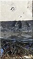
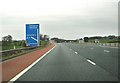
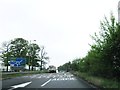
Benchmark on south end of eastern parapet of A7 bridge over M6
Ordnance Survey rivet benchmark levelled at 34.854m above Newlyn Datum verified in 1972
Image: © Luke Shaw
Taken: 15 Apr 2021
0.17 miles
9
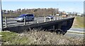
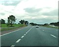
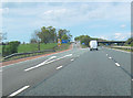
Bridge taking A7 over M6 Motorway
There is an Ordnance Survey benchmark Image on top of the bridge edge at its left hand end
Image: © Luke Shaw
Taken: 15 Apr 2021
0.18 miles