IMAGES TAKEN NEAR TO
Rottington, WHITEHAVEN, CA28 9UR
Introduction
This page details the photographs taken nearby to CA28 9UR by members of the Geograph project.
The Geograph project started in 2005 with the aim of publishing, organising and preserving representative images for every square kilometre of Great Britain, Ireland and the Isle of Man.

There are currently over 7.5m images from over14,400 individuals and you can help contribute to the project by visiting https://www.geograph.org.uk
Image Map
Images are licensed for reuse under creativecommons.org/licenses/by-sa/2.0
Notes
- Clicking on the map will re-center to the selected point.
- The higher the marker number, the further away the image location is from the centre of the postcode.
Image Listing (5 Images Found)
Images are licensed for reuse under creativecommons.org/licenses/by-sa/2.0
Image
Details
Distance
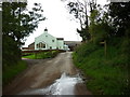
1
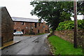
Rottington
This is the main road through the village. The building ahead is occupied by Whistling Jacks Guesthouse.
Image: © Bill Boaden
Taken: 19 Jul 2010
0.06 miles

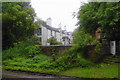
5

Benchmark
Benchmark on a wall as you enter Rottington from the north
Image: © Karen Kelso
Taken: 18 Mar 2023
0.23 miles