IMAGES TAKEN NEAR TO
Woodside Mews, WHITEHAVEN, CA28 9UN
Introduction
This page details the photographs taken nearby to Woodside Mews, CA28 9UN by members of the Geograph project.
The Geograph project started in 2005 with the aim of publishing, organising and preserving representative images for every square kilometre of Great Britain, Ireland and the Isle of Man.

There are currently over 7.5m images from over14,400 individuals and you can help contribute to the project by visiting https://www.geograph.org.uk
Image Map
Images are licensed for reuse under creativecommons.org/licenses/by-sa/2.0
Notes
- Clicking on the map will re-center to the selected point.
- The higher the marker number, the further away the image location is from the centre of the postcode.
Image Listing (7 Images Found)
Images are licensed for reuse under creativecommons.org/licenses/by-sa/2.0
Image
Details
Distance
1
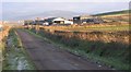
Bell House Farm.
The farmers need to feed the animals and a drive for efficiency means the larger plastic wrapped animal feed bundles are now a common sight on the landscape.
Image: © John Holmes
Taken: 27 Dec 2005
0.07 miles
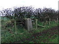
2
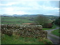
Path at Bell House Farm
Part of the Coast to Coast walk with Dent Hill in the background
Image: © Adie Jackson
Taken: 26 Nov 2006
0.11 miles

4
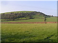
Stanley
View west from the Coast-to-Coast path near Stanley Pond, with the railway on a low embankment in the foreground.
Image: © Dave Dunford
Taken: 15 Oct 2006
0.16 miles
5
B5345 St Bees Road at Whitehaven boundary
Image: © Colin Pyle
Taken: 5 Sep 2021
0.18 miles
7

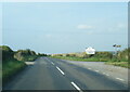
Road to St Bees
The B5345 crosses arable land just south of Whitehaven bound for St Bees.
Image: © Richard Webb
Taken: Unknown
0.24 miles