IMAGES TAKEN NEAR TO
Sandwith, WHITEHAVEN, CA28 9UF
Introduction
This page details the photographs taken nearby to CA28 9UF by members of the Geograph project.
The Geograph project started in 2005 with the aim of publishing, organising and preserving representative images for every square kilometre of Great Britain, Ireland and the Isle of Man.

There are currently over 7.5m images from over14,400 individuals and you can help contribute to the project by visiting https://www.geograph.org.uk
Image Map
Images are licensed for reuse under creativecommons.org/licenses/by-sa/2.0
Notes
- Clicking on the map will re-center to the selected point.
- The higher the marker number, the further away the image location is from the centre of the postcode.
Image Listing (9 Images Found)
Images are licensed for reuse under creativecommons.org/licenses/by-sa/2.0
Image
Details
Distance
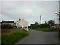
2

Mid Town Farm
Now split into two separate houses, but once a farm house with cartshed attached.
Image: © Matthew Hatton
Taken: 19 May 2015
0.21 miles
4
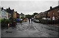
Main Street, Sandwith
This view would not have changed very much over the years apart from the presence of cars.
Image: © Bill Boaden
Taken: 19 Jul 2010
0.22 miles
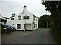

7

Former Inn in Sandwith
The whitewashed building is the former Lowther Arms public house.
It is a fine example of an 18thC vernacular building.
Image: © Matthew Hatton
Taken: 19 May 2015
0.22 miles
8
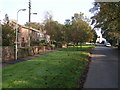
Sandwith
Looking along the main street towards the Dog and Partridge pub.
Image: © Dave Dunford
Taken: 15 Oct 2006
0.22 miles
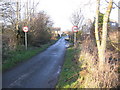
9

Sandwith village
A private road but public footpath leads from here to St Bees Head.
Image: © David Purchase
Taken: 14 Oct 2019
0.23 miles