IMAGES TAKEN NEAR TO
Hill Top Road, WHITEHAVEN, CA28 9ED
Introduction
This page details the photographs taken nearby to Hill Top Road, CA28 9ED by members of the Geograph project.
The Geograph project started in 2005 with the aim of publishing, organising and preserving representative images for every square kilometre of Great Britain, Ireland and the Isle of Man.

There are currently over 7.5m images from over14,400 individuals and you can help contribute to the project by visiting https://www.geograph.org.uk
Image Map
Images are licensed for reuse under creativecommons.org/licenses/by-sa/2.0
Notes
- Clicking on the map will re-center to the selected point.
- The higher the marker number, the further away the image location is from the centre of the postcode.
Image Listing (6 Images Found)
Images are licensed for reuse under creativecommons.org/licenses/by-sa/2.0
Image
Details
Distance
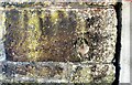
3
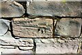
Benchmark on stone in wall on east side of Meadow View
Ordnance Survey records indicate that the benchmark was levelled at 21.251m above Newlyn Datum, verified in 1965
Image: © Luke Shaw
Taken: 25 Aug 2019
0.21 miles
4
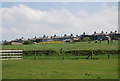
View across Ginns (B5345)
There is an Ordnance Survey benchmark Image on a stone in the wall at its junction with the wooden fence
Image: © Luke Shaw
Taken: 25 Aug 2019
0.21 miles
5
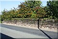
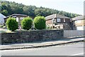
Stone wall and hawthorns on east side of Meadow View (opposite No. 1)
There is an Ordnance Survey benchmark Image on a stone in the wall about 3m from its left hand end where it has a junction
Image: © Luke Shaw
Taken: 25 Aug 2019
0.21 miles
6
Benchmark on west side of Ginns
Ordnance Survey cut mark benchmark levelled at 20.117m above Newlyn Datum verified 1965
Image: © Luke Shaw
Taken: 25 Aug 2019
0.21 miles