IMAGES TAKEN NEAR TO
Colliers Way, WHITEHAVEN, CA28 9BH
Introduction
This page details the photographs taken nearby to Colliers Way, CA28 9BH by members of the Geograph project.
The Geograph project started in 2005 with the aim of publishing, organising and preserving representative images for every square kilometre of Great Britain, Ireland and the Isle of Man.

There are currently over 7.5m images from over14,400 individuals and you can help contribute to the project by visiting https://www.geograph.org.uk
Image Map
Images are licensed for reuse under creativecommons.org/licenses/by-sa/2.0
Notes
- Clicking on the map will re-center to the selected point.
- The higher the marker number, the further away the image location is from the centre of the postcode.
Image Listing (17 Images Found)
Images are licensed for reuse under creativecommons.org/licenses/by-sa/2.0
Image
Details
Distance
1
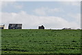
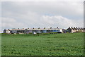
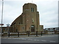
The Church at Kells across fields of wheat
Image: © N Chadwick
Taken: 29 May 2009
0.07 miles
2
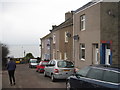
South Row, Kells
Looking westwards, towards the sea.
Image: © David Medcalf
Taken: 7 Feb 2013
0.07 miles
3
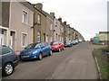
South Row, Kells
I assume that this square of accurately, if unimaginatively, named roads [North Row, South Row, West Row and Mid Street] was an early 'town planning' effort for this miners' village. There does not appear to be an East Row.
Image: © David Medcalf
Taken: 7 Feb 2013
0.08 miles
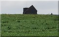
5
West Row & South Row, Kells
These terraced houses were built to house the miners working at the nearby Kells pit (now long closed)
Image: © N Chadwick
Taken: 29 May 2009
0.11 miles
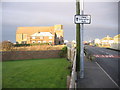
7

The cycle path near West Row
Looking westwards, towards the sea.
Image: © David Medcalf
Taken: 7 Feb 2013
0.12 miles
8
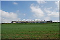
West Row, Kells
These terraced houses were built to house the miners working at the , now closed, Kells pit. North Row & South Row can also be seen in the photo.
Image: © N Chadwick
Taken: 29 May 2009
0.12 miles
10
View of South Row Kells Whitehaven.
Foreground evidence of the drains from the chemical plant into the sea that was blamed for making the sea froth.
Image: © John Holmes
Taken: 14 Jan 2006
0.16 miles