IMAGES TAKEN NEAR TO
Kestrel Grove, WHITEHAVEN, CA28 8XP
Introduction
This page details the photographs taken nearby to Kestrel Grove, CA28 8XP by members of the Geograph project.
The Geograph project started in 2005 with the aim of publishing, organising and preserving representative images for every square kilometre of Great Britain, Ireland and the Isle of Man.

There are currently over 7.5m images from over14,400 individuals and you can help contribute to the project by visiting https://www.geograph.org.uk
Image Map
Images are licensed for reuse under creativecommons.org/licenses/by-sa/2.0
Notes
- Clicking on the map will re-center to the selected point.
- The higher the marker number, the further away the image location is from the centre of the postcode.
Image Listing (4 Images Found)
Images are licensed for reuse under creativecommons.org/licenses/by-sa/2.0
Image
Details
Distance
1
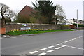
Junction of School Brow with Moresby Parks Road
There is an OS benchmark Image on a stone in the roadside wall at its end near the left edge of the image
Image: © Luke Shaw
Taken: 19 Apr 2018
0.14 miles
2
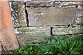
Benchmark on wall on east side of Moresby Parks Road
Image: © Luke Shaw
Taken: 19 Apr 2018
0.16 miles
3
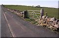
Field gateway on north side of School Brow
There is an OS benchmark Image on the inside face of the stone gatepost at the far side of the gateway
Image: © Roger Templeman
Taken: 9 Apr 2018
0.18 miles
4
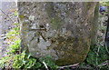
Benchmark on stone gatepost on north side of School Brow
Ordnance Survey cut mark benchmark levelled at 141.223m above Newlyn Datum
Image: © Roger Templeman
Taken: 9 Apr 2018
0.18 miles