IMAGES TAKEN NEAR TO
Valley Park, WHITEHAVEN, CA28 8BA
Introduction
This page details the photographs taken nearby to Valley Park, CA28 8BA by members of the Geograph project.
The Geograph project started in 2005 with the aim of publishing, organising and preserving representative images for every square kilometre of Great Britain, Ireland and the Isle of Man.

There are currently over 7.5m images from over14,400 individuals and you can help contribute to the project by visiting https://www.geograph.org.uk
Image Map (Loading...)


Getting Data...Please wait
Leaflet Map data © OpenStreetMap
Images are licensed for reuse under creativecommons.org/licenses/by-sa/2.0
Notes
- Clicking on the map will re-center to the selected point.
- The higher the marker number, the further away the image location is from the centre of the postcode.
Image Listing (4 Images Found)
Images are licensed for reuse under creativecommons.org/licenses/by-sa/2.0
Image
Details
Distance
4
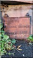
Old Milestone by B5295, Hensingham Road, Whitehaven parish
Whitehaven plate stone by the UC road (was A595), in parish of Whitehaven (Copeland District), Hensingham Road, built into roadside wall at pavement level, opposite the Lowther Arms PH.
Inscription reads:-
TO
CALDER BRIDGE
8½ MILES
Surveyed
Milestone Society National ID: CU_WHCB01
Image: © Tim Pugh
Taken: 1 Sep 2016
0.20 miles