IMAGES TAKEN NEAR TO
Calder Avenue, WHITEHAVEN, CA28 8AT
Introduction
This page details the photographs taken nearby to Calder Avenue, CA28 8AT by members of the Geograph project.
The Geograph project started in 2005 with the aim of publishing, organising and preserving representative images for every square kilometre of Great Britain, Ireland and the Isle of Man.

There are currently over 7.5m images from over14,400 individuals and you can help contribute to the project by visiting https://www.geograph.org.uk
Image Map
Images are licensed for reuse under creativecommons.org/licenses/by-sa/2.0
Notes
- Clicking on the map will re-center to the selected point.
- The higher the marker number, the further away the image location is from the centre of the postcode.
Image Listing (16 Images Found)
Images are licensed for reuse under creativecommons.org/licenses/by-sa/2.0
Image
Details
Distance
1
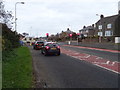
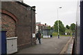
C2C Cycleway under the railway at Corckickle
A well used cycle track at the beginning of a long trans pennine cycle route.
Image: © John Holmes
Taken: 16 Nov 2005
0.11 miles
2
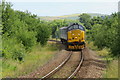
Train Approaching Corkickle Railway Station
A locomotive hauled train, on lease to Northern from DRS to help improve capacity on the Cumbrian Coast route, is seen approaching Corkickle station.
Image: © David Robinson
Taken: 13 Jul 2016
0.13 miles
3
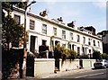
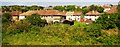
Terrace In Whitehaven
Houses on Inkerman Terrace in Whitehaven looking East-south east.
Image: © Brian Balfe
Taken: Unknown
0.14 miles
4
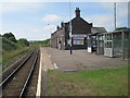
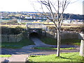
Corkickle railway station, Cumbria
Opened in 1855 by the Whitehaven & Furness Junction Railway on the line from Barrow-in-Furness to Carlisle. View south towards St. Bees and Barrow.
Image: © Nigel Thompson
Taken: 14 Jul 2013
0.17 miles
8
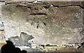
Benchmark on wall on NE side of Back Corkickle
Ordnance Survey documents indicate that the cut mark benchmark was levelled at 25.110m above Newlyn Datum in 1961
Image: © Luke Shaw
Taken: 25 Aug 2019
0.21 miles
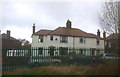
9
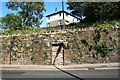
Wall on NE side of Back Corkickle (A5094) and house above
There is an Ordnance Survey benchmark Image on the second stone above the pavement on the wall right of the blocked doorway
Image: © Luke Shaw
Taken: 25 Aug 2019
0.22 miles