IMAGES TAKEN NEAR TO
Flatt Walks, WHITEHAVEN, CA28 7RW
Introduction
This page details the photographs taken nearby to Flatt Walks, CA28 7RW by members of the Geograph project.
The Geograph project started in 2005 with the aim of publishing, organising and preserving representative images for every square kilometre of Great Britain, Ireland and the Isle of Man.

There are currently over 7.5m images from over14,400 individuals and you can help contribute to the project by visiting https://www.geograph.org.uk
Image Map
Images are licensed for reuse under creativecommons.org/licenses/by-sa/2.0
Notes
- Clicking on the map will re-center to the selected point.
- The higher the marker number, the further away the image location is from the centre of the postcode.
Image Listing (40 Images Found)
Images are licensed for reuse under creativecommons.org/licenses/by-sa/2.0
Image
Details
Distance
1
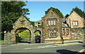
Park Lodge and entrance arch from Back Corkickle opposite Coach Road
Image: © Roger Templeman
Taken: 25 Aug 2019
0.07 miles
2

Village Signpost
Mounted on a stone wall beside a gateway on the east side of the A5094 Back Corkickle in Whitehaven parish.
Milestone Society National ID: CU_NX9717V
Image: © Roger Templeman
Taken: 25 Aug 2019
0.07 miles

5
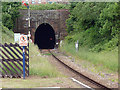
Single line tunnel at Corkickle
The line between Corkickle and Whitehaven stations runs in the 1322 yard tunnel which ends immediately before Whitehaven station.
Image: © John Lucas
Taken: 25 Jun 2013
0.10 miles
6
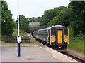
A Carlisle bound train enters the tunnel at Corkickle
Image: © John Lucas
Taken: 25 Jun 2013
0.10 miles
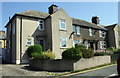
7
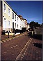
Sunny Day In Whitehaven
Houses on Front Corkickle looking up the hill on a sunny day.
Image: © Brian Balfe
Taken: Unknown
0.10 miles
8
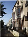
Front Corkickle, Whitehaven
The gardens are the other side of the narrow road from the houses
Image: © John Lord
Taken: 9 Sep 2009
0.12 miles
10
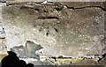
Benchmark on wall on NE side of Back Corkickle
Ordnance Survey documents indicate that the cut mark benchmark was levelled at 25.110m above Newlyn Datum in 1961
Image: © Luke Shaw
Taken: 25 Aug 2019
0.14 miles