IMAGES TAKEN NEAR TO
Flatt Walks, WHITEHAVEN, CA28 7RA
Introduction
This page details the photographs taken nearby to Flatt Walks, CA28 7RA by members of the Geograph project.
The Geograph project started in 2005 with the aim of publishing, organising and preserving representative images for every square kilometre of Great Britain, Ireland and the Isle of Man.

There are currently over 7.5m images from over14,400 individuals and you can help contribute to the project by visiting https://www.geograph.org.uk
Image Map
Images are licensed for reuse under creativecommons.org/licenses/by-sa/2.0
Notes
- Clicking on the map will re-center to the selected point.
- The higher the marker number, the further away the image location is from the centre of the postcode.
Image Listing (53 Images Found)
Images are licensed for reuse under creativecommons.org/licenses/by-sa/2.0
Image
Details
Distance
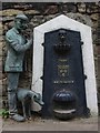
2
A statue and a nineteenth century drinking fountain, Lowther Street, Whitehaven
Image: © habiloid
Taken: 13 Aug 2019
0.09 miles
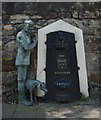
5
Victorian drinking fountain, Whitehaven
Victorian drinking fountain with modern sculpture addition, part of the Whitehaven sculpture trail. Art works by John McKenna. More at this http://www.a4a.co.uk/sailorswhitehave.html.
Image: © Jim Osley
Taken: 27 Jun 2014
0.11 miles
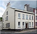
7
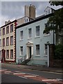
Town house, Lowther Street
Grade II listed town house, described at this http://list.english-heritage.org.uk/resultsingle.aspx?uid=1335989.
Image: © Jim Osley
Taken: 27 Jun 2014
0.11 miles
8
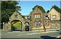
Park Lodge and entrance arch from Back Corkickle opposite Coach Road
Image: © Roger Templeman
Taken: 25 Aug 2019
0.12 miles
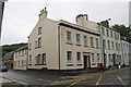
9
Town house, Lowther Street
Grade II listed town house, described at http://list.english-heritage.org.uk/resultsingle.aspx?uid=1335989.
Image: © Jim Osley
Taken: 27 Jun 2014
0.12 miles
10
Junction of Lowther Street and Catherine Street
There is an OS benchmark Image on the angle of the building right of the black down pipe
Image: © Roger Templeman
Taken: 21 Jun 2012
0.12 miles