IMAGES TAKEN NEAR TO
Peter Street, WHITEHAVEN, CA28 7PR
Introduction
This page details the photographs taken nearby to Peter Street, CA28 7PR by members of the Geograph project.
The Geograph project started in 2005 with the aim of publishing, organising and preserving representative images for every square kilometre of Great Britain, Ireland and the Isle of Man.

There are currently over 7.5m images from over14,400 individuals and you can help contribute to the project by visiting https://www.geograph.org.uk
Image Map
Images are licensed for reuse under creativecommons.org/licenses/by-sa/2.0
Notes
- Clicking on the map will re-center to the selected point.
- The higher the marker number, the further away the image location is from the centre of the postcode.
Image Listing (132 Images Found)
Images are licensed for reuse under creativecommons.org/licenses/by-sa/2.0
Image
Details
Distance
1
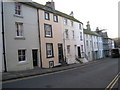
Houses in Scotch Street, Whitehaven
Image: © Jonathan Thacker
Taken: 17 Nov 2009
0.06 miles
2
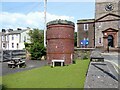
Air Shaft No.5, Whitehaven Tunnel
The Grade II listed air shaft cap is in the grounds of St James’ Community Centre at the corner of Queen Street and High Street opposite St James Church (see photograph Image).
The ventilation shaft was used in the construction of Whitehaven Tunnel which opened to railway traffic on the 29 September 1852 (see also photograph Image).
Image: © Adrian Taylor
Taken: 1 Jun 2021
0.07 miles
3
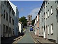
Queen Street
With St James at the top the street runs down to the town centre.
Image: © Stanley Walker
Taken: 18 Jun 2007
0.07 miles
4
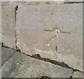
Ordnance Survey 1GL Bolt
This OS Bolt can be found on the Church of St James. It marks a point 30.9860m above mean sea level.
Image: © Adrian Dust
Taken: 15 Feb 2018
0.07 miles
5
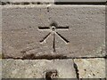
Benchmark, St James' Church, Whitehaven
Detail of the Ordnance Survey 1GL bolt benchmark on a stone quoin at the south west corner of St James’ Church tower. The benchmark marks a height of 30.9860m above sea level (Ordnance Datum Newlyn) last verified in 1965 (location photograph Image).
Image: © Adrian Taylor
Taken: 1 Jun 2021
0.07 miles
6
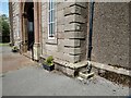
St James' Church, Whitehaven
Detail of the west end of St James’ Church. There is an Ordnance Survey bolt benchmark on one of the stone quoins (photograph Image).
Image: © Adrian Taylor
Taken: 1 Jun 2021
0.07 miles
7
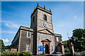
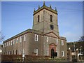
St. James Church, Whitehaven
Intersected Station https://trigpointing.uk/trig/10770
It stands in an elevated position overlooking the town. The church was built in 1752–53 at a cost of £3,400 (equivalent to £550,000 in 2021)
https://en.wikipedia.org/wiki/St_James%27_Church,_Whitehaven
Image: © Brian Deegan
Taken: 17 Sep 2022
0.07 miles
8
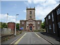
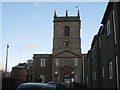
St James' Church, Whitehaven
Designed in the Neoclassical style and probably designed by the architect Christopher Myers, St James’ Church was dedicated on 25 July 1753 and is Grade I listed. The tower contains a peal of 12 bells, the last two being added in 1998.
The small circular brick tower is a ventilation shaft cap for Whitehaven Tunnel (photograph at Image).
Image: © Adrian Taylor
Taken: 1 Jun 2021
0.07 miles
10
St James, Whitehaven
Built 1752-3.
Image: © Jonathan Thacker
Taken: 17 Nov 2009
0.07 miles