IMAGES TAKEN NEAR TO
Temple Terrace, WHITEHAVEN, CA28 7PB
Introduction
This page details the photographs taken nearby to Temple Terrace, CA28 7PB by members of the Geograph project.
The Geograph project started in 2005 with the aim of publishing, organising and preserving representative images for every square kilometre of Great Britain, Ireland and the Isle of Man.

There are currently over 7.5m images from over14,400 individuals and you can help contribute to the project by visiting https://www.geograph.org.uk
Image Map
Images are licensed for reuse under creativecommons.org/licenses/by-sa/2.0
Notes
- Clicking on the map will re-center to the selected point.
- The higher the marker number, the further away the image location is from the centre of the postcode.
Image Listing (97 Images Found)
Images are licensed for reuse under creativecommons.org/licenses/by-sa/2.0
Image
Details
Distance
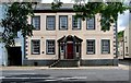
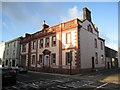
1
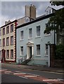
Town house, Lowther Street
Grade II listed town house, described at this http://list.english-heritage.org.uk/resultsingle.aspx?uid=1335989.
Image: © Jim Osley
Taken: 27 Jun 2014
0.06 miles
2
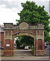
"Fire Brigade Station" entrance
These days the entrance to the Whitehaven Archive and Local Studies Centre building, converted from the fire station.
Image: © Jim Osley
Taken: 27 Jun 2014
0.06 miles
3
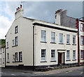
Town house, Lowther Street
Grade II listed town house, described at http://list.english-heritage.org.uk/resultsingle.aspx?uid=1335989.
Image: © Jim Osley
Taken: 27 Jun 2014
0.06 miles
4
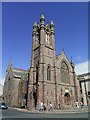
Lowther Street Methodist Church
The builder used Eskdale Granite to build the church giving it an unusual textured finish.
Image: © Stanley Walker
Taken: 18 Jun 2007
0.06 miles
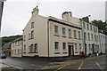
5
80 Lowther Street, Whitehaven
One of 19 Grade II listed buildings along Lowther Street, described at this http://list.english-heritage.org.uk/resultsingle.aspx?uid=1279543. Currently the home of Whitehaven Rugby League Supporters Club.
Image: © Jim Osley
Taken: 27 Jun 2014
0.06 miles
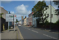
6
Junction of Lowther Street and Catherine Street
There is an OS benchmark Image on the angle of the building right of the black down pipe
Image: © Roger Templeman
Taken: 21 Jun 2012
0.07 miles
7
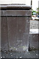
Benchmark on #81 Lowther Street
Ordnance Survey cut mark benchmark described on the Bench Mark Database at http://www.bench-marks.org.uk/bm43736
Image: © Roger Templeman
Taken: 21 Jun 2012
0.07 miles
9
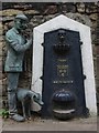
Victorian drinking fountain, Whitehaven
Victorian drinking fountain with modern sculpture addition, part of the Whitehaven sculpture trail. Art works by John McKenna. More at this http://www.a4a.co.uk/sailorswhitehave.html.
Image: © Jim Osley
Taken: 27 Jun 2014
0.07 miles
10
House in Scotch Street, Whitehaven
A finely detailed eighteenth century house. .
Image: © Jonathan Thacker
Taken: 17 Nov 2009
0.08 miles